NWS Albany - Heavy Rain Threat Monday Night into Tuesday Morning - issued Saturday, June 8, 2019 - 530 PM

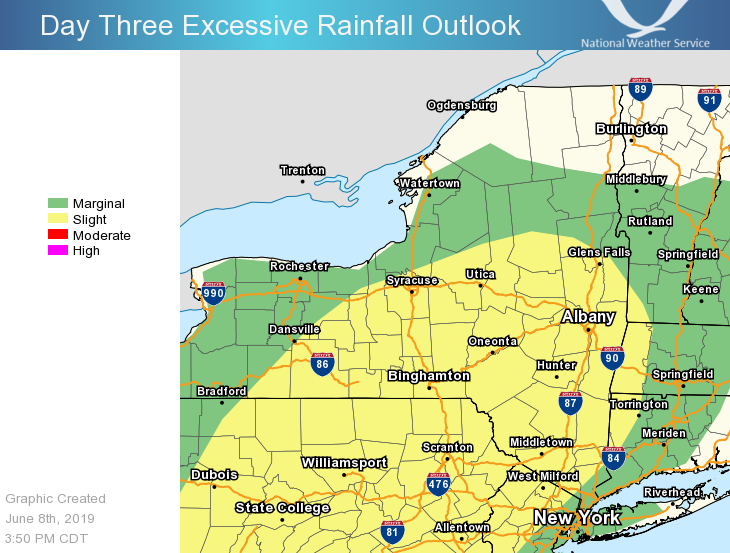
**** The information in this email pertains to the following areas only:**** *- In Connecticut: Litchfield County* *- In Massachusetts: Berkshire County* *- In Vermont: Bennington & Windham Counties* *- In New York: Albany, Columbia, Dutchess, Fulton, Hamilton, Herkimer, Montgomery, Greene, Rensselaer, Saratoga, Schenectady, Schoharie, Ulster, Warren and Washington Counties* Dear Emergency Managers and other partners, Rain and embedded thunderstorms may produce heavy downpours Monday Night into Tuesday morning. This may lead to ponding of water in poor drainage/urban and low lying areas where the heaviest rain occurs. Isolated flash flooding is possible. The attached graphic depicts the area where the threat for heavier rain and possible ponding of water is expected. If you have any questions, feel free to contact us: 1. Email: alb.stormreport@noaa.gov 2. NWSChat at https://nwschat.weather.gov/live/ 3. Social Media: Facebook <https://www.facebook.com/NWSAlbany> and Twitter <https://twitter.com/NWSAlbany> 4. Telephone: (518) 435-9575 <518-435-9575> Sincerely, NWS Albany www.weather.gov/albany
participants (1)
-
 ALB Stormreport - NOAA Service Account