NWS Albany - Severe Thunderstorm Watch in Effect Until 9 PM - Monday, May 20, 2019 - 215 PM

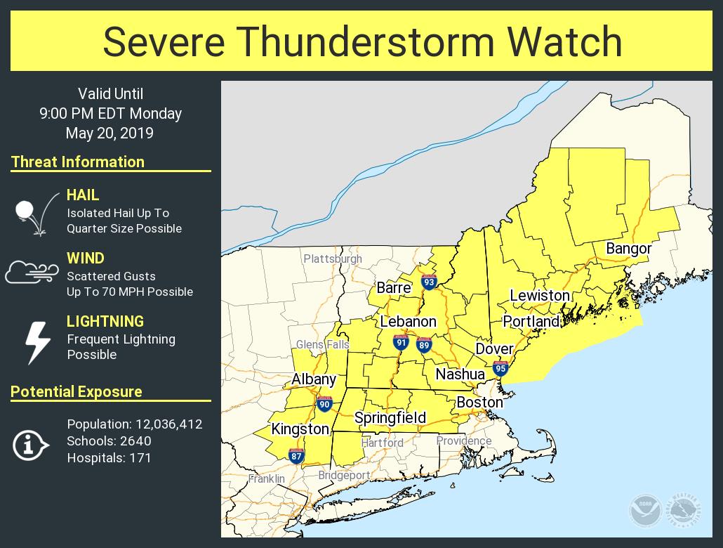
**** The information in this email pertains to the following areas only:**** *- In Massachusetts: Berkshire County* *-In Connecticut: Litchfield County* *- In Vermont: Bennington & Windham Counties* *- In New York: Albany, Columbia, Dutchess, Greene, Rensselaer, Saratoga, Schenectady, Ulster, and Washington Counties* Dear Emergency Managers and other partners, A Severe Thunderstorm Watch has been issued for the eastern Catskills, Mid Hudson Valley, Taconics, Capital Region, Saratoga Region, Southern VT, Berkshires & Northwestern Connecticut through 9 PM. Thunderstorms are in the process of developing over the region. Heavy rain, frequent lightning and damaging winds are the main threat with any thunderstorm. Large hail cannot be ruled out within the strongest storms as well. Be alert for any possible warnings this afternoon into this evening. Attached is an image of the Severe Thunderstorm Watch area. If you have any questions, please feel free to contact us via: 1. Email: alb.stormreport@noaa.gov 2. NWSChat at https://nwschat.weather.gov/live/ 3. Social Media: Facebook <https://www.facebook.com/NWSAlbany> and Twitter <https://twitter.com/NWSAlbany> 4. Telephone: (518) 435-9575 <518-435-9575> Sincerely, NWS Albany www.weather.gov/albany
participants (1)
-
 ALB Stormreport - NOAA Service Account