[2022.12.21AM] NWS Boston EM Briefing: Impactful Storm Fri-Sat

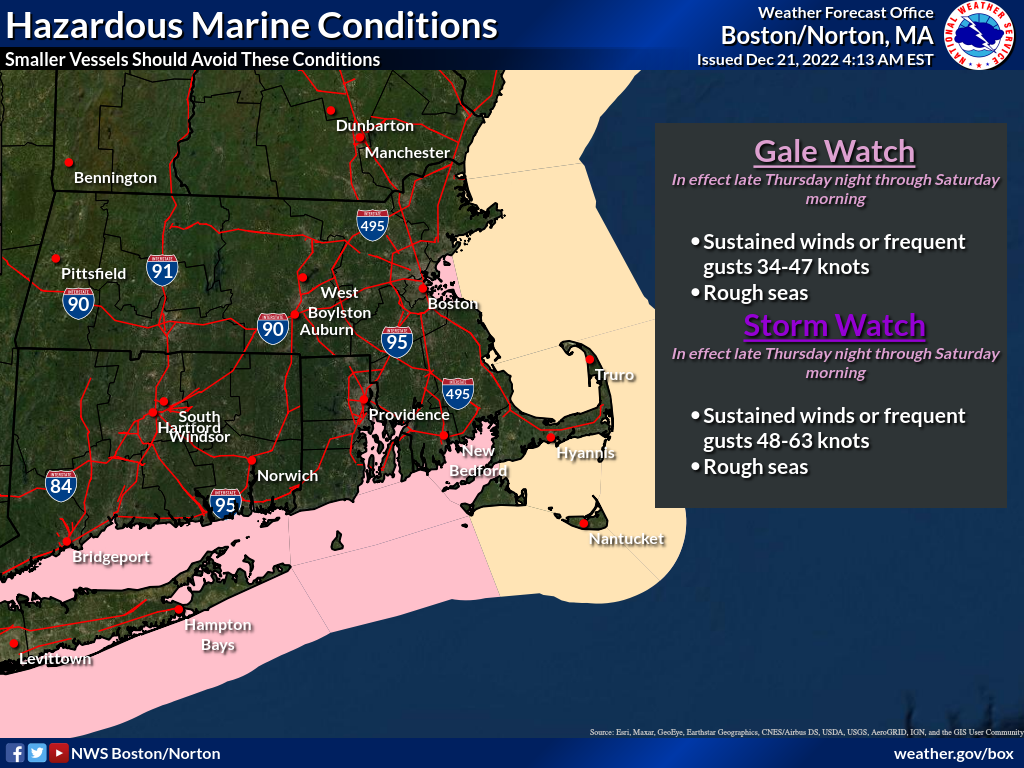
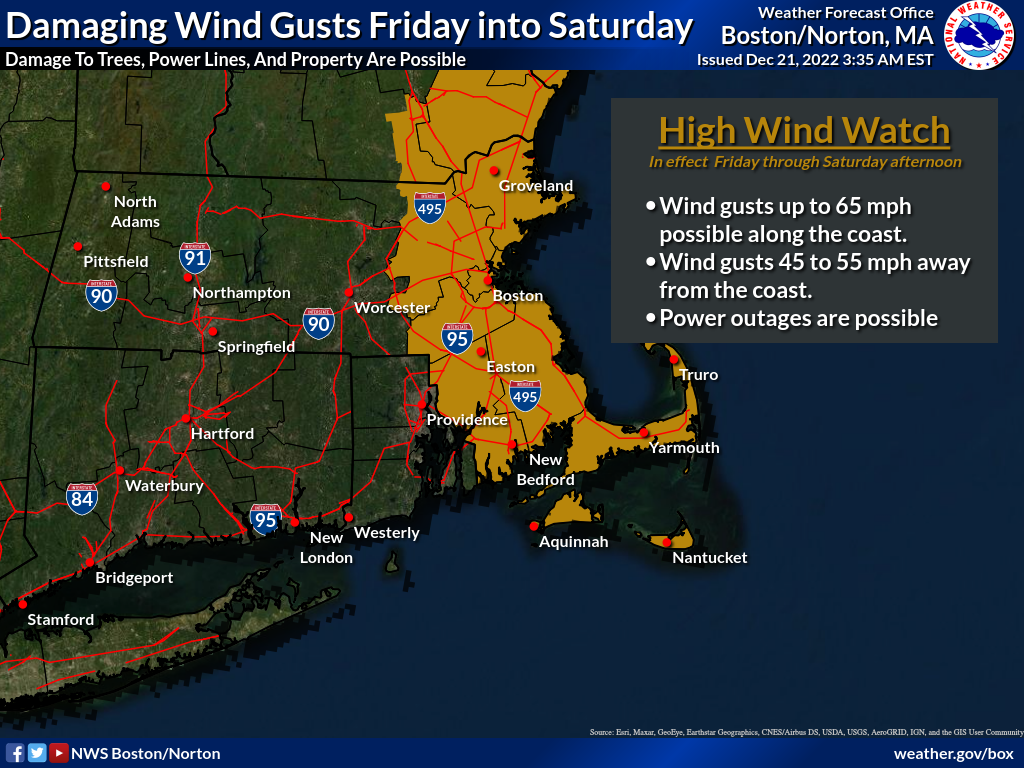
Good morning, we continue to monitor an impactful storm that will affect holiday travel from Friday into Saturday. Overall the forecast remains similar to the previous briefing. *What is new:* - *A High Wind Watch was issued for all of eastern Massachusetts from Friday through Saturday afternoon. *[image: High_Wind_Watch.png] - *Gale Watch and Storm Watch were issued for all waters from Friday through Saturday. *[image: Hazardous_Marine_Conditions.png] - *Rainfall is slightly higher, generally 1.5" to 2.5", with locally higher amounts. * As previously discussed, the main concerns include: - Damaging winds up to 65 MPH Friday from the south or southeast, and strong west/southwest winds up to 45 MPH Saturday, which could affect power restoration efforts. - Minor to Moderate coastal flooding along parts of both the east and south coasts during the Friday morning high tide, and for the south coast during the evening high tide. - Minor river flooding, especially along the mainstem Connecticut River. Minor flooding refers to flooding less than one foot deep and is primarily confined to low-lying areas. - Hazardous winds and seas for marine travel. Meteorologists Torry Gaucher and Matt Belk Thank you, If you have any questions or would like more information, don't hesitate to contact us via this email address, on NWSChat <https://nwschat.weather.gov/>, or at the following: National Weather Service Boston/Norton, MA 46 Commerce Way Norton, MA 02766 508.622.3280 Website <http://www.weather.gov/boston> | Facebook <http://www.facebook.com/NWSBoston> | Twitter <http://www.twitter.com/NWSBoston>
Hello, This secondary email contains the updated briefing package to include wind direction with the 6-hourly wind gusts. We apologize for the additional email. Meteorologists Torry Gaucher and Matt Belk If you have any questions or would like more information, don't hesitate to contact us via this email address, on NWSChat <https://nwschat.weather.gov/>, or at the following: National Weather Service Boston/Norton, MA 46 Commerce Way Norton, MA 02766 508.622.3280 Website <http://www.weather.gov/boston> | Facebook <http://www.facebook.com/NWSBoston> | Twitter <http://www.twitter.com/NWSBoston> On Wed, Dec 21, 2022 at 4:46 AM BOX Operations - NOAA Service Account < box.operations@noaa.gov> wrote:
Good morning, we continue to monitor an impactful storm that will affect holiday travel from Friday into Saturday. Overall the forecast remains similar to the previous briefing.
*What is new:*
- *A High Wind Watch was issued for all of eastern Massachusetts from Friday through Saturday afternoon. *[image: High_Wind_Watch.png] - *Gale Watch and Storm Watch were issued for all waters from Friday through Saturday. *[image: Hazardous_Marine_Conditions.png] - *Rainfall is slightly higher, generally 1.5" to 2.5", with locally higher amounts. *
As previously discussed, the main concerns include:
- Damaging winds up to 65 MPH Friday from the south or southeast, and strong west/southwest winds up to 45 MPH Saturday, which could affect power restoration efforts. - Minor to Moderate coastal flooding along parts of both the east and south coasts during the Friday morning high tide, and for the south coast during the evening high tide. - Minor river flooding, especially along the mainstem Connecticut River. Minor flooding refers to flooding less than one foot deep and is primarily confined to low-lying areas. - Hazardous winds and seas for marine travel.
Meteorologists Torry Gaucher and Matt Belk
Thank you, If you have any questions or would like more information, don't hesitate to contact us via this email address, on NWSChat <https://nwschat.weather.gov/>, or at the following:
National Weather Service Boston/Norton, MA 46 Commerce Way Norton, MA 02766 508.622.3280 Website <http://www.weather.gov/boston> | Facebook <http://www.facebook.com/NWSBoston> | Twitter <http://www.twitter.com/NWSBoston>
participants (1)
-
 BOX Operations - NOAA Service Account