NWS Boston EM Briefing: Late Week Flood Potential

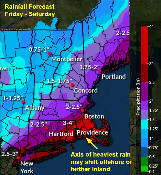
Good Afternoon Everyone, Given the recent attention on Subtropical Storm Nicole, currently well off the east coast of Florida, we wanted to provide an early heads up on potential impacts to southern New England later this week. See the attached one-page briefing and preliminary rainfall forecast for details. Here are the Key Points: 1. Nicole, or more likely its remnants, may move quickly through southern New England sometime in the Friday to Saturday time frame. It may bring heavy rain and gusty winds. 2. Potential impacts include flooding of urban areas and smaller rivers and streams. Minor wind damage, such as downed branches, is also possible. 3. Marine impacts are possible with this system as well. Gale force winds and rough seas may lead to hazardous conditions for vessels, especially on the offshore waters. Keep in mind there will likely be changes in the forecast over the next few days, especially with respect to the location and amounts of the heaviest rainfall. We will provide an updated email briefing Tuesday afternoon. In the meantime, if you have any questions or would like more information, don't hesitate to contact us by phone, via this email address, or on NWSChat <https://nwschat.weather.gov/>. Thanks, Joe Dellicarpini and Hayden Frank National Weather Service Boston/Norton, MA 46 Commerce Way Norton, MA 02766 508.622.3280 Website <http://www.weather.gov/boston> | Facebook <http://www.facebook.com/NWSBoston> | Twitter <http://www.twitter.com/NWSBoston>
participants (1)
-
 BOX Operations - NOAA Service Account