[2023.02.20 PM] NWS Boston EM Briefing: Multiple Wintry Weather Events This Week

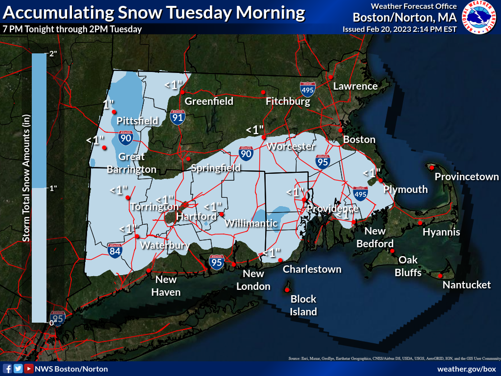
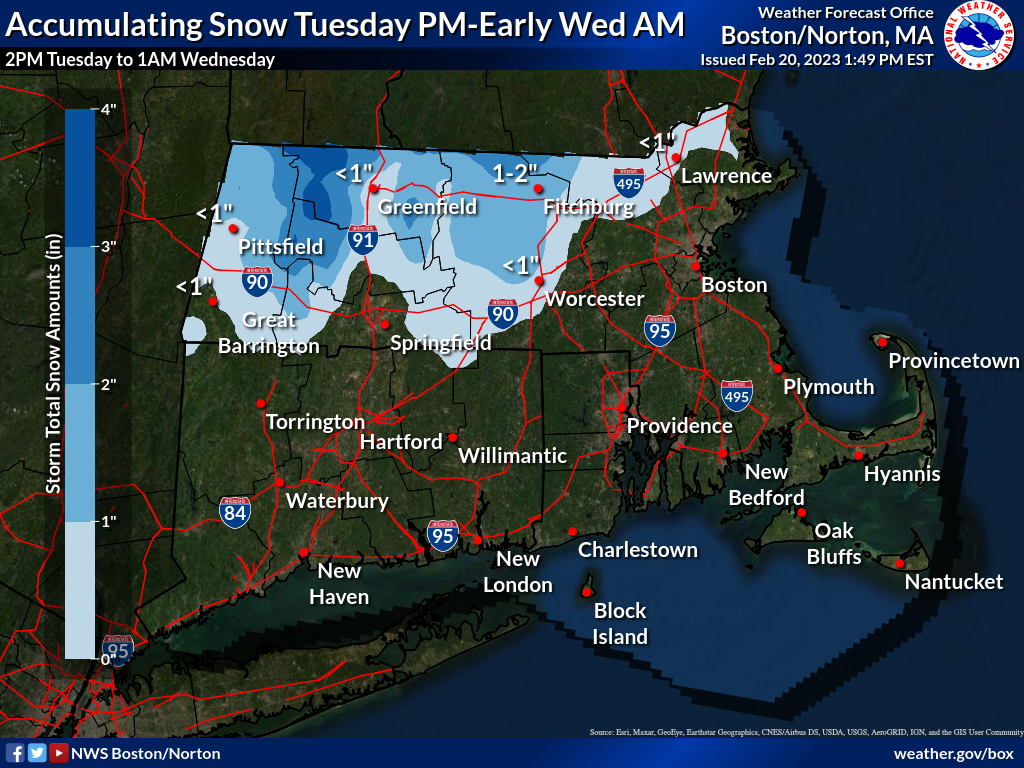
Good afternoon, We are looking at a fairly active period of weather for the workweek, with multiple periods of wintry weather to contend with. We have two generally minor/nuisance events, overnight tonight into Tuesday morning and another for Tuesday late afternoon into Tuesday night. However a more significant winter storm then looks to affect Southern New England Wednesday night through Thursday night involving accumulating snow, sleet and freezing rain. It is this latter storm system which has the greatest concern for widespread wintry weather impacts this week. Each storm will be discussed below: *Storm #1: Overnight into Early Tuesday AM [CT, RI and Southeast MA] * A weak and fast-moving low pressure moving across our southern coastal waters overnight tonight into early Tuesday morning to spread steady light snow (or brief rain at the onset then changing to steady light snow) across Connecticut, Rhode Island and into southeast Massachusetts. While snow accumulations with this fast-moving storm are limited to no more than 2 inches, snow will be falling during the morning commute and could pose difficult travel for commuters during the Tuesday morning commute, including reduced visibility and possible slushy, slippery roads. Image below shows our latest snow forecast for overnight tonight into Tuesday morning: [image: snowtues.png] *Confidence*: High confidence on snow occurring, but lower on the northern extent of minor accumulations and the total accumulations. Much of what falls will be on grassy surfaces, with slushy accumulation on paved surfaces. *Storm #2: Tuesday Late Afternoon to Tuesday Night [Mainly North and West of I-495]* The next fairly weak and fast-moving storm then moves in later Tuesday afternoon into Tuesday night. While mainly plain rain is anticipated for Connecticut, Rhode Island and eastern and southeast Massachusetts, temperatures should be cold enough for minor accumulating snow in the Merrimack Valley, central Massachusetts and into the Berkshires in western Massachusetts. Coatings to up to 2 inches of new snow appear to be common, with local/isolated amounts up to 4 inches in the Berkshires. We expect accumulating snow to end shortly after midnight. Following image is our snowfall expectations for Tuesday late afternoon to Tuesday night: [image: snowtueswed.png] *Confidence: *High on the event occurring, but moderate on the total accumulations. Greatest accumulation potential mainly in the higher terrain. Snow will likely be wet and slushy. *Storm #3: Wednesday Night through Thursday Night [All of Southern New England, but especially along and north of Interstate 95]. * A stationary front lying in the vicinity of Southern New England to lift northward Wednesday night through Thursday night, bringing a mix of wintry precipitation types to the area. Forecast remains little changed from that which was briefed early this morning. Accumulations of snow, sleet and/or freezing rain are all possible, with the potential for adverse impacts. It still is too early to provide specific details on precipitation type changeovers and forecast accumulations as yet. Attached is our one-page briefing which was previously sent and remains valid at this time. *Confidence*: Moderate to high on the event occurring, but low on snow/sleet and ice amounts. Snow/sleet and ice amounts will be sensitive to small changes in temperatures and the storm's track, and thus could vary, perhaps significantly. Expect an update to this briefing *no later than Tuesday morning*. Thank You! Meteorologists: Kristie Smith, Torry Gaucher and Andrew Loconto If you have any questions or would like more information, don't hesitate to contact us via this email address, on NWSChat <https://nwschat.weather.gov/>, or at the following: National Weather Service Boston/Norton, MA 46 Commerce Way Norton, MA 02766 508.622.3280 Website <http://www.weather.gov/boston> | Facebook <http://www.facebook.com/NWSBoston> | Twitter <http://www.twitter.com/NWSBoston>
participants (1)
-
 BOX Operations - NOAA Service Account