[2020-04-03 AM] NWS Boston EM Briefing: Strong/Damaging Winds, Minor to Moderate Coastal Flooding for eastern MA, Cape Cod & the Islands

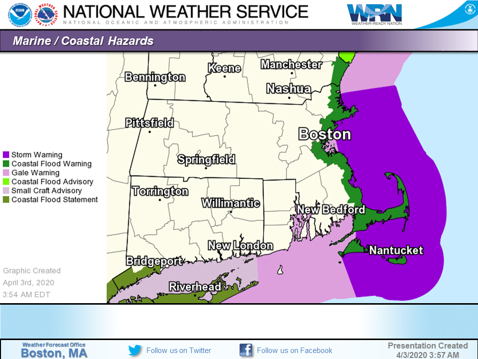
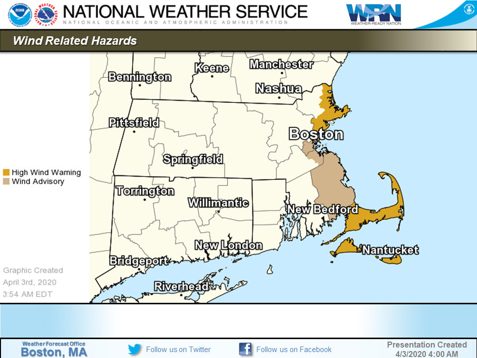
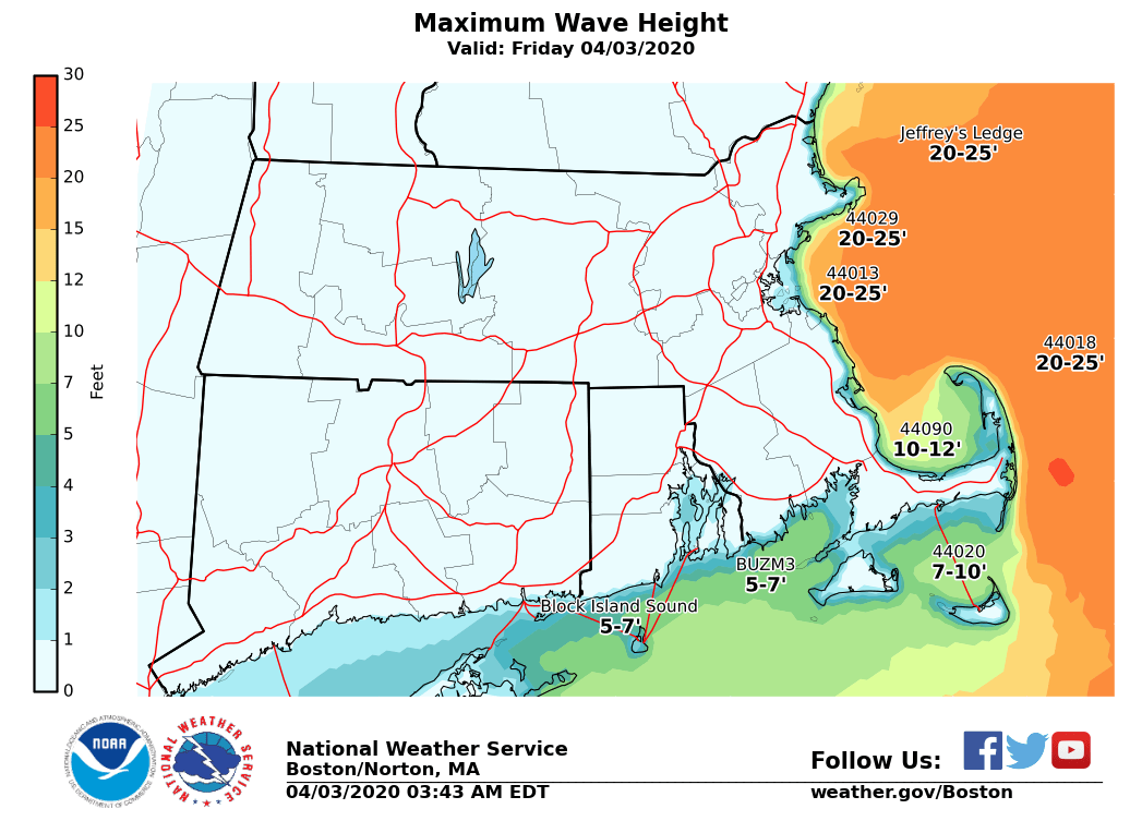
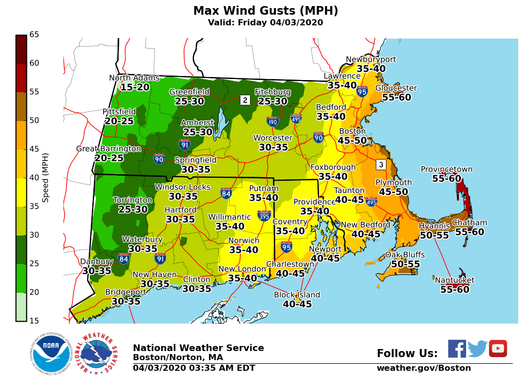
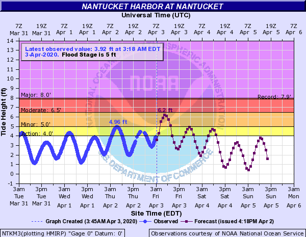
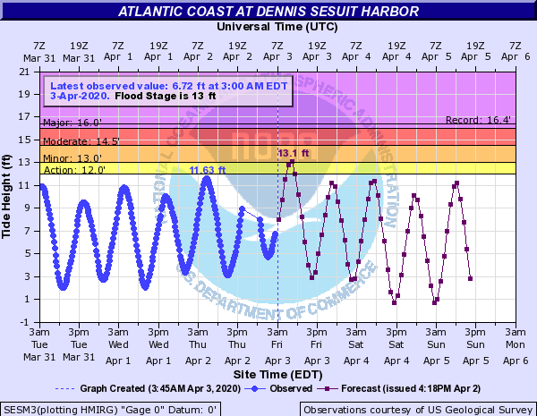
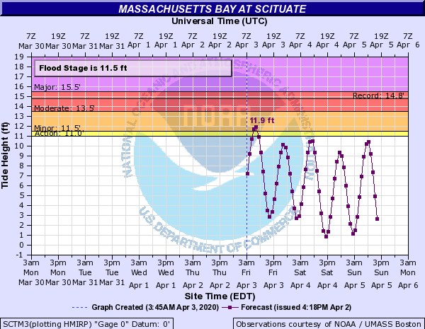
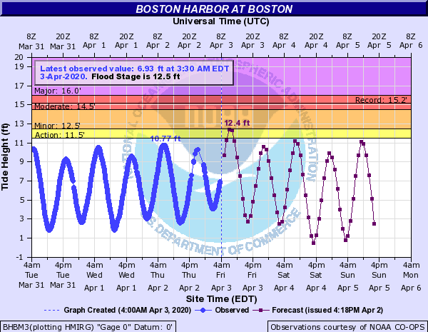
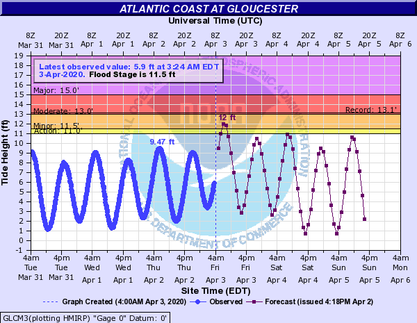
Good morning, Here is the latest update on strong/damaging winds and coastal flooding today across eastern MA. *Changes from previous forecast* ...* High Wind Warning expanded to include Cape Ann (Rockport, Manchester & Gloucester) & Wind Advisory expanded into Boston & into western Plymouth county* *Headlines:* - High Wind Warning*: *In effect from early Friday morning through Friday evening for Cape Cod, Nantucket, Martha's Vineyard and Cape Ann. - *Wind Advisory*: In effect from early Friday morning through Friday evening for Plymouth county to Boston - *Coastal Flood Warning*: In effect for Friday morning's high tide for all of the east coast of MA, including Nantucket and Martha's Vineyard - Storm Warning: In effect early Friday morning thru Friday evening, for the coastal waters east of Ipswich Bay and Stellwagen Bank National Marine Sanctuary and the offshore waters adjacent Cape Cod and the Islands (excluding Buzzards Bay and Vineyard Sound). - *Gale Warning*: In effect early Friday morning thru Friday evening, for the remaining waters. *Details:* *Coastal Flooding: * *Friday Morning: Widespread Minor with pockets of moderate coastal flooding* - *Locations*: entire eastern MA coastline from the NH/MA border to Nantucket. This includes the coastline of Boston, Cape Cod and the Islands. - *Timing*: From 6 AM to 10 AM Friday morning. - *Impacts/Inundation*: For Nantucket: One to two feet of inundation above ground level possible. For east coastal Mass including Cape Cod and Martha's Vineyard, up to one foot of inundation above ground level is possible. - *Confidence and Uncertainty: *High confidence on widespread minor coastal flooding but some uncertainty on areal extent of moderate flooding. The greatest confidence for moderate coastal flooding is at Nantucket. If higher winds and waves occur then more widespread moderate coastal flooding will occur. Conversely if wind and waves trend lower than moderate coastal flooding will not be as widespread. - *Friday Evening & Saturday Morning High Tides:* minor coastal flooding is possible during these high tide cycles along the entire eastern MA coastline. Thus a Coastal Flood Advisory may be needed for these two tide cycles. *COASTAL FLOOD DEFINITIONS ...* Minor Coastal Flooding - Flooding of the most vulnerable shore roads and/or basements due to height of storm tide or wave splash over. - Majority of roads remain passable with only isolated closures due to nuisance flooding or rip rap. - Isolated inundation up to a foot is possible. - There is no significant threat to life and any impact on property is minimal. - This type of event is covered by a Coastal Flood Advisory. Moderate Coastal Flooding - Widespread flooding of vulnerable shore roads and/or basements due to height of storm tide and/or wave action. - Numerous road closures are needed. - Lives may be at risk for people who put themselves in harm’s way. - Isolated damage of very vulnerable structures such as docks or house decks/porches near the high tide line may be observed. - Pockets of inundation up to 3 feet above ground are likely. - This type of event is covered by a Coastal Flood Warning. The link below provides Coastal Flood Threat and Inundation Mapping ... https://www.weather.gov/box/coastal *Strong to Damaging Winds: * - *Locations: *Cape Cod, the Islands and east coastal Mass. - *Timing: *Strongest north to northeast winds occur today between roughly 8 am and 4 pm. - *Winds*: gusts up to 60 mph for Cape Cod, the islands and Cape Ann, and up to 50 mph for east coastal Mass. - *Impacts: *Possible downed trees and power lines. - *Confidence and Uncertainty*: highest confidence for damaging winds is across Cape Cod, the Islands and Cape Ann with wind gusts at or exceeding 60 mph is most likely. A second area of concern is coastal Plymouth county where winds may be just as strong. Frank Nocera If you have any questions or would like more information, don't hesitate to contact us via this email address, on NWSChat <https://nwschat.weather.gov/>, or at the following: National Weather Service Boston/Norton, MA 46 Commerce Way Norton, MA 02766 508.622.3280 Website <http://www.weather.gov/boston> | Facebook <http://www.facebook.com/NWSBoston> | Twitter <http://www.twitter.com/NWSBoston>
participants (1)
-
 BOX Operations - NOAA Service Account