[2019.01.29 AM NWS Briefing] Accumulating Snow Late Today Into Tonight, Snow Squall Threat/Strong Winds later Wednesday Followed By Bitterly Cold Wind Chills

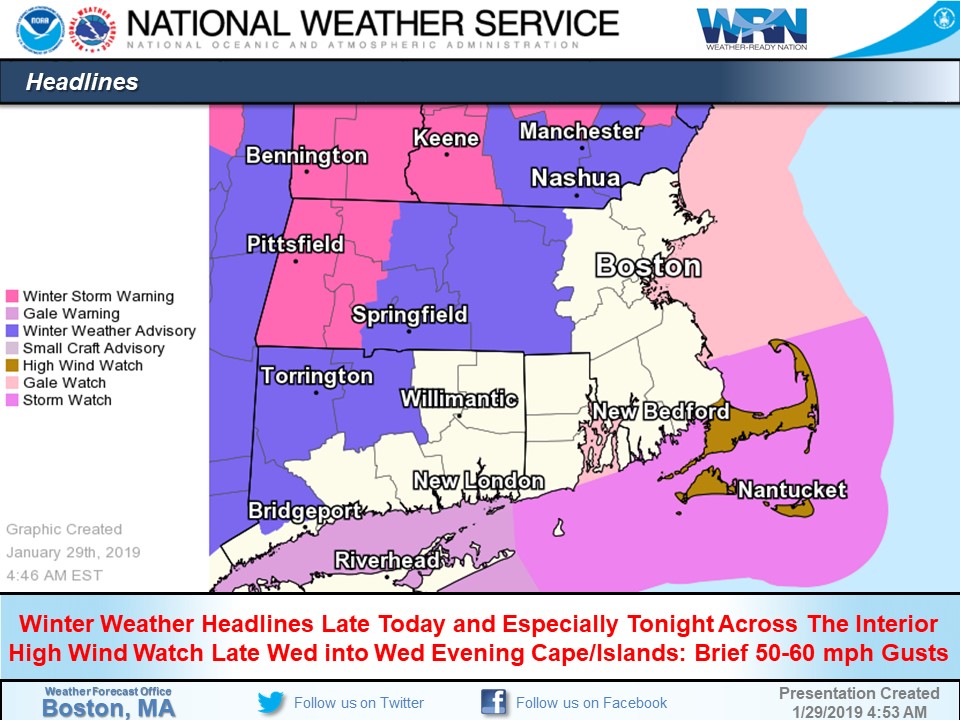
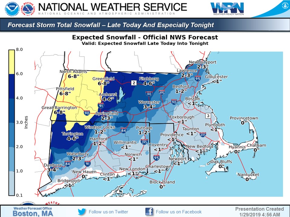
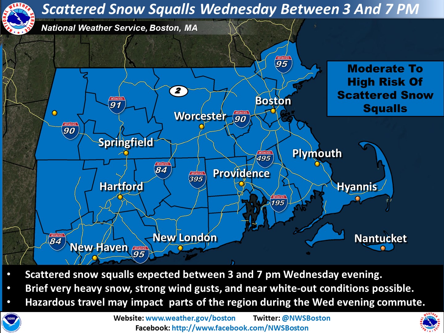
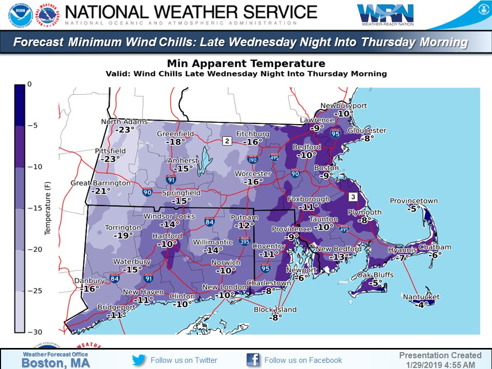
Good morning Here are the main weather concerns/impacts later today into Thursday morning. We have attached a few brief slides highlighting the main concerns. *Accumulating Snow late today into tonight: * - Precipitation overspreads western MA northern CT between 3 and 6 pm this evening, reaching eastern MA/RI after 6 or 7 pm. - Precipitation type mainly rain along and southeast of a Boston to Providence, to Hartford line after a brief period of snow possible at the onset. Any snow accumulations generally less than 1 inch. - Mainly snow expected northwest of a Bradley CT, to Worcester MA, to Bedford MA line. Snow accumulations of 2 to 5 inches anticipated, except 4 to 8 inches in the Berkshires. - Precipitation ends from west to east between 2 and 5 am Wednesday morning. Locations that change to rain may see precipitation end as a brief period of snow, mainly across northern CT and interior MA. - Dry weather anticipated for the Wednesday morning commute, but untreated roads across the interior may remain slippery. *Localized Snow Squalls/Brief Strong to Damaging Wind Gusts Wednesday Afternoon and Evening:* - Scattered snow squalls anticipated between 3 and 7 pm Wednesday evening. These squalls may contain briefly very heavy snow, strong winds, near white-out conditions, and hazardous travel for the Wed evening commute. - Brief 35 to 55 mph wind gusts possible Wednesday afternoon and evening in most locations and between 50 and 60 mph across the Cape/Islands. - High Wind Watch posted for the Cape and Islands. Wind Advisories may eventually be needed elsewhere. *Bitterly Cold Wind Chills Late Wednesday night into Thursday Morning:* - Wind chills drop to between 10 and 25 below zero late Wednesday night into Thursday morning. - Wind Chill Advisories will likely be needed for a good portion of the region with possible Wind Chill Warnings for portion of the higher terrain of Massachusetts. *Marine Headlines:* - Gale and Storm Watches hoisted for all waters Wednesday afternoon and evening for a period of 40 to 50 knot wind gusts. - Moderate to heavy freezing spray expected Wednesday night into Thursday night across the open waters Please let us know if you have any questions or concerns. Thank You Meteorologist: Hayden Frank If you have any questions or would like more information, don't hesitate to contact us via this email address, on NWSChat <https://nwschat.weather.gov/>, or at the following: National Weather Service Boston/Norton, MA 46 Commerce Way Norton, MA 02766 508.622.3280 Website <http://www.weather.gov/boston> | Facebook <http://www.facebook.com/NWSBoston> | Twitter <http://www.twitter.com/NWSBoston>
participants (1)
-
 BOX Operations - NOAA Service Account