[2018.12.19 NWS Briefing] Potential Heavy Rain/Flooding and Strong Winds

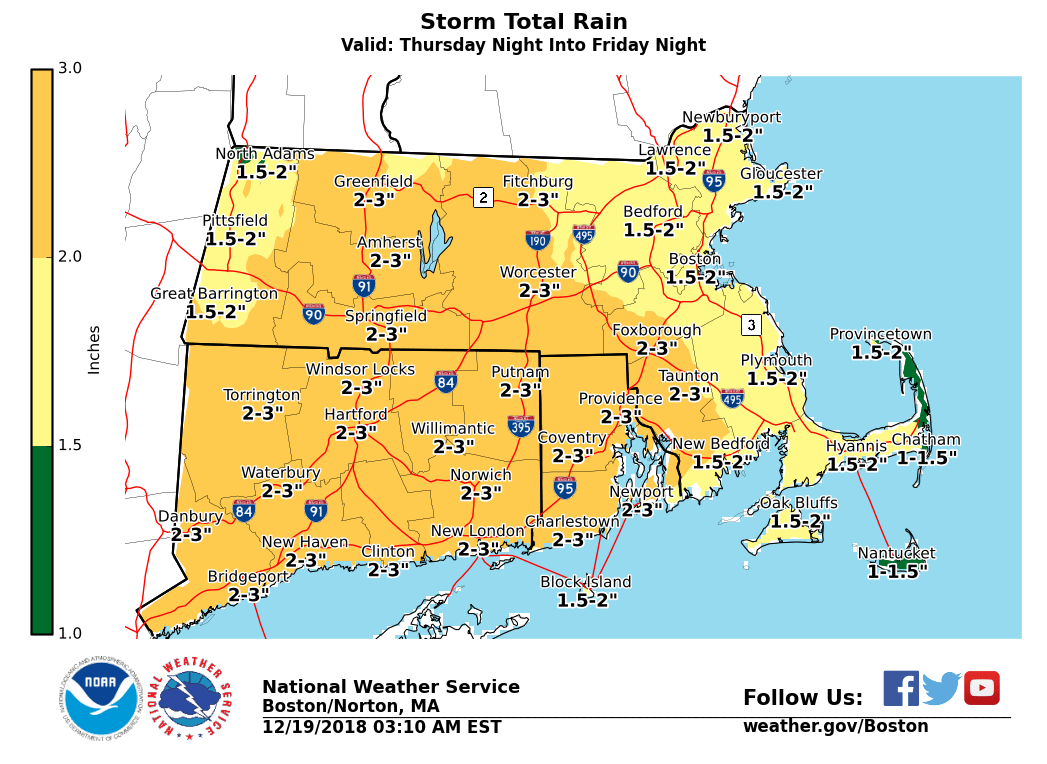
Good morning everyone, No significant changes to the forecast for late Thursday night into Friday. Heavy rain, strong winds and a risk for coastal flooding remain the primary concerns. At this time, only a Gale Watch for the waters has been issued beginning early Friday morning, however it is possible more headlines will be issued. *What / Where / When ...* - Heavy rainfall across all Southern New England - Rain starts late Thursday night, with heaviest rainfall expected early Friday into Friday afternoon, possibly lingering into Friday evening. - Rainfall amounts of 1.5 to 3 inches, with locally higher amounts possible. - Heavy rainfall will likely result in urban and poor drainage flooding, along with some river flooding as well. Moderate river flooding is possible if rainfall approaches 3 inches. - Strong southerly winds - The greatest risk for strong to damaging winds will be across SE New Eng, particularly RI and southeast MA and Cape/Islands during the daylight hours Friday, possibly into Friday evening. - Potential for wind gusts over 50 mph. - If strong winds are realized, tree damage and isolated to scattered power outages will be possible. - Minor coastal flooding along the south coast - Mainly during the early Friday evening high tide. - Storm surge around 2 ft possible with 12+ foot seas just offshore. - Minor flooding possible along the shores of Narragansett Bay and Buzzards Bay, as well as splashover and minor flooding along ocean exposed south coastal beaches. *Uncertainty ...* - Heavy rainfall: High confidence that heavy rainfall will occur, but there is uncertainty with respect to where the axis of heavy rainfall will set up and timing of the heaviest rainfall. - Strong winds: Uncertainty in the strength of the winds along the south coast and extent of any wind damage, and also the timing of the strongest winds. - Coastal flooding: There is uncertainty if there will be enough storm surge during the Friday evening high tide to produce minor flooding. We will continue to update over the next 48 hours. If you have any questions or would like more information, don't hesitate to contact us via this email address, on NWSChat <https://nwschat.weather.gov/>, or at the following: National Weather Service Boston/Norton, MA 46 Commerce Way Norton, MA 02766 508.622.3280 Website <http://www.weather.gov/boston> | Facebook <http://www.facebook.com/NWSBoston> | Twitter <http://www.twitter.com/NWSBoston>
participants (1)
-
 BOX Operations - NOAA Service Account