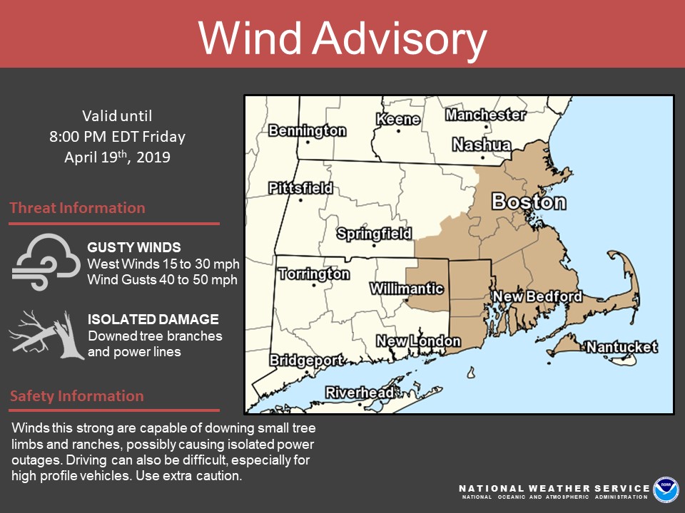
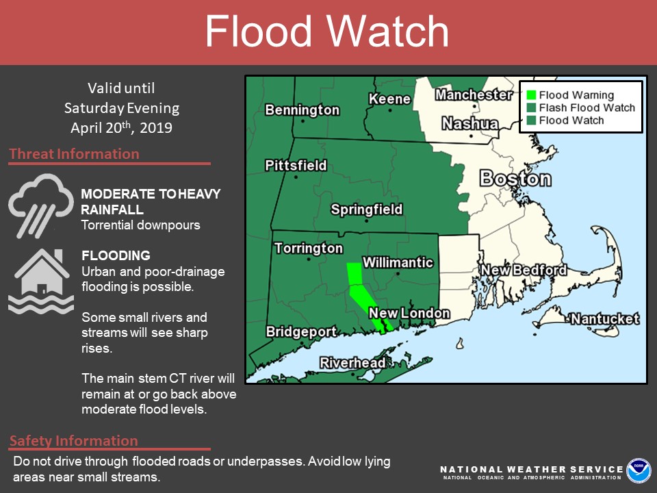
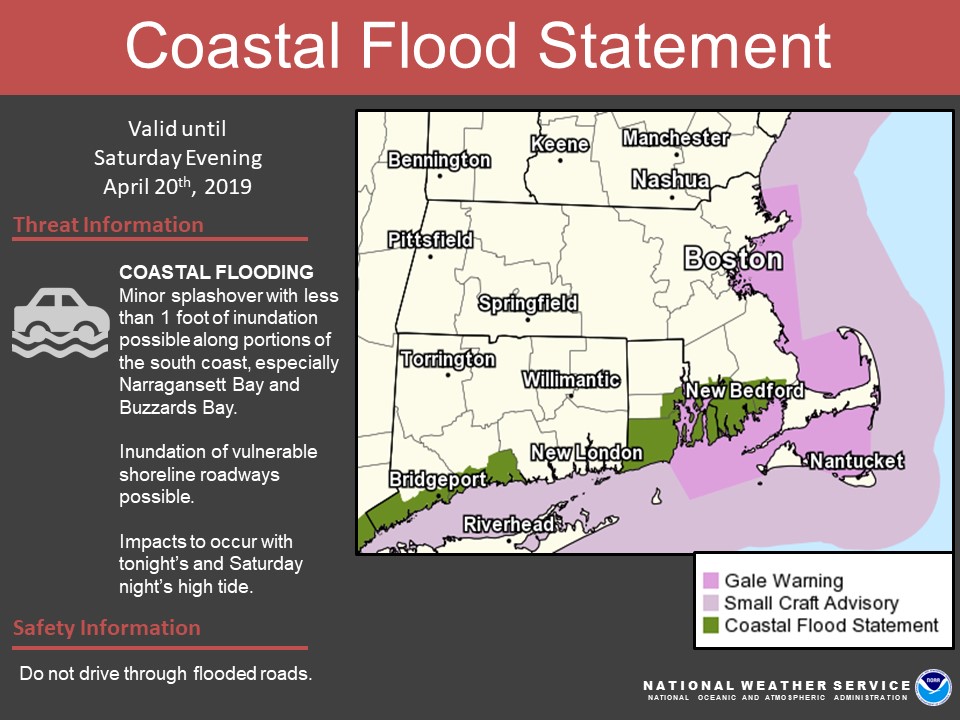
[2019.04.19 PM] Interior / River / Coastal Flooding ...

Good afternoon, Widespread rain with embedded heavier showers, perhaps even some thunderstorms, are expected to develop late tonight and continue through Saturday evening. Rainfall amounts of 1 to 2 inches is forecast with the potential for locally higher values up around 2.5 inches. *What / Where / When ...* - Gusty SW winds: - A WIND ADVISORY remains in effect for eastern and southeastern MA as well as all of RI into early evening. - Southwest winds sustained around 15 to 25 mph with gusts up to 50 mph. - Already have received several reports across the advised area of downed limbs. The threat for downed limbs continue, possibly small trees as well. - Interior flooding: - With the possibility of urban and poor-drainage flooding, the FLOOD WATCH continues for western and central MA, all of CT where heaviest rainfall is forecast (please see the attached *storm total rainfall* image). - River Flooding: - In addition to snow melt further upstream, heavy rainfall will exacerbate main stem flooding along the Connecticut River with most locations remaining at or going back above moderate flood levels. - It may also contribute to sharp rises for a few smaller streams throughout the area. - For more specific details, please see NWS river forecasts at: https://water.weather.gov/ahps2/index.php?wfo=box - Coastal Flooding: - Strong southerly winds will result in a storm surge of up to 1 foot. Coincident with high astronomical tides, the threat of minor splashover remains possible along portions of the south coast of RI and MA, especially Narragansett Bay and Buzzards Bay. - A COASTAL FLOOD STATEMENT remains in effect for tonight and again Saturday night during peak high tides. Respectfully, Benjamin Sipprell Meteorologist NWS Boston / Norton If you have any questions or would like more information, don't hesitate to contact us via this email address, on NWSChat <https://nwschat.weather.gov/>, or at the following: National Weather Service Boston/Norton, MA 46 Commerce Way Norton, MA 02766 508.622.3280 Website <http://www.weather.gov/boston> | Facebook <http://www.facebook.com/NWSBoston> | Twitter <http://www.twitter.com/NWSBoston>
Correction, Apologies. For the Connecticut River, flooding will remain at or go back above *MINOR* flood stage. Not moderate. Again, our apologies for the error. Respectfully, Benjamin Sipprell Meteorologist NWS Boston / Norton If you have any questions or would like more information, don't hesitate to contact us via this email address, on NWSChat <https://nwschat.weather.gov/>, or at the following: National Weather Service Boston/Norton, MA 46 Commerce Way Norton, MA 02766 508.622.3280 Website <http://www.weather.gov/boston> | Facebook <http://www.facebook.com/NWSBoston> | Twitter <http://www.twitter.com/NWSBoston> On Fri, Apr 19, 2019 at 4:19 PM BOX Operations - NOAA Service Account < box.operations@noaa.gov> wrote:
Good afternoon,
Widespread rain with embedded heavier showers, perhaps even some thunderstorms, are expected to develop late tonight and continue through Saturday evening. Rainfall amounts of 1 to 2 inches is forecast with the potential for locally higher values up around 2.5 inches.
*What / Where / When ...*
- Gusty SW winds: - A WIND ADVISORY remains in effect for eastern and southeastern MA as well as all of RI into early evening. - Southwest winds sustained around 15 to 25 mph with gusts up to 50 mph. - Already have received several reports across the advised area of downed limbs. The threat for downed limbs continue, possibly small trees as well.
- Interior flooding:
- With the possibility of urban and poor-drainage flooding, the FLOOD WATCH continues for western and central MA, all of CT where heaviest rainfall is forecast (please see the attached *storm total rainfall* image).
- River Flooding:
- In addition to snow melt further upstream, heavy rainfall will exacerbate main stem flooding along the Connecticut River with most locations remaining at or going back above moderate flood levels. - It may also contribute to sharp rises for a few smaller streams throughout the area. - For more specific details, please see NWS river forecasts at: https://water.weather.gov/ahps2/index.php?wfo=box
- Coastal Flooding:
- Strong southerly winds will result in a storm surge of up to 1 foot. Coincident with high astronomical tides, the threat of minor splashover remains possible along portions of the south coast of RI and MA, especially Narragansett Bay and Buzzards Bay. - A COASTAL FLOOD STATEMENT remains in effect for tonight and again Saturday night during peak high tides.
Respectfully,
Benjamin Sipprell Meteorologist NWS Boston / Norton
If you have any questions or would like more information, don't hesitate to contact us via this email address, on NWSChat <https://nwschat.weather.gov/>, or at the following:
National Weather Service Boston/Norton, MA 46 Commerce Way Norton, MA 02766 508.622.3280 Website <http://www.weather.gov/boston> | Facebook <http://www.facebook.com/NWSBoston> | Twitter <http://www.twitter.com/NWSBoston>
participants (1)
-
 BOX Operations - NOAA Service Account