Re: [Weather] [2020-04-13 AM] NWS Boston EM Briefing for Damaging Winds/Thunderstorms on Monday

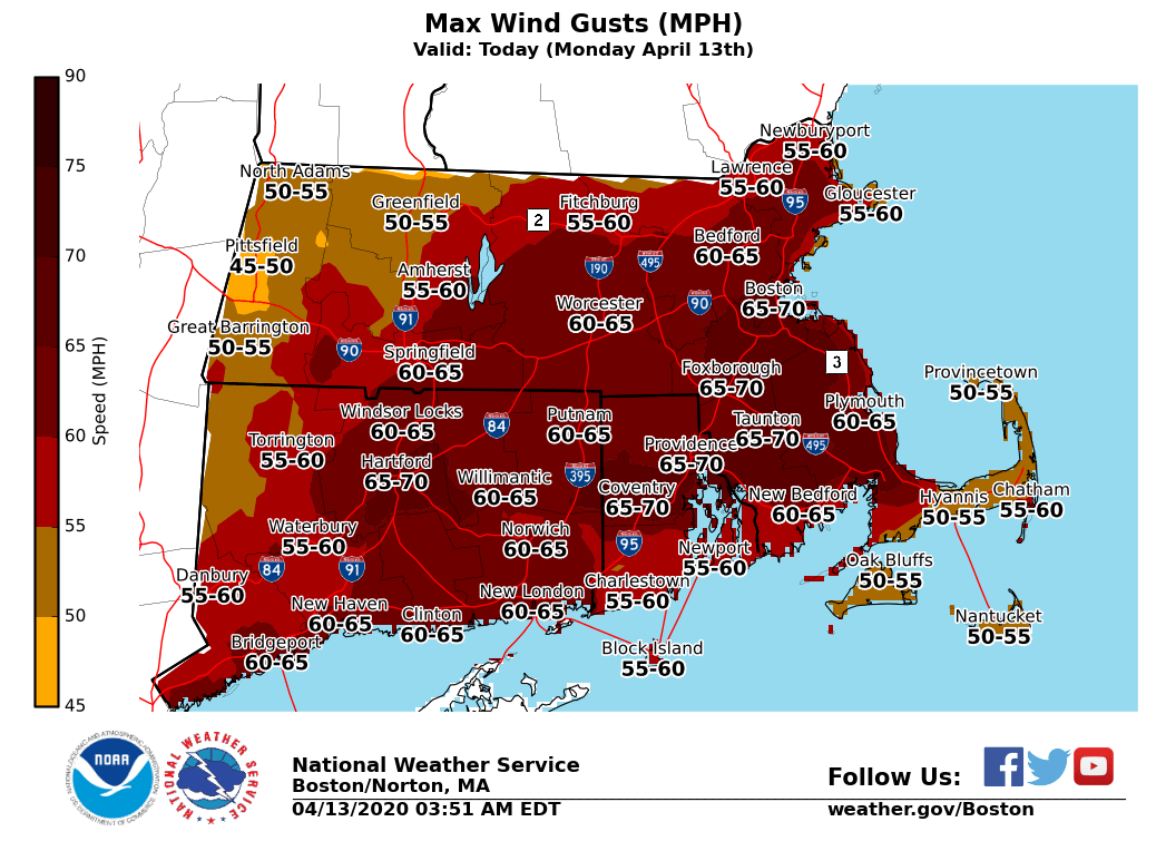
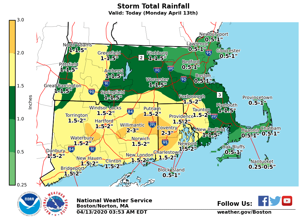
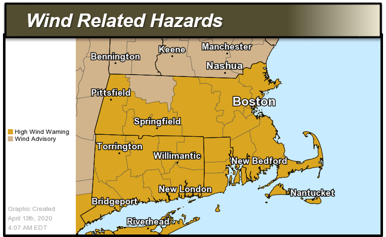
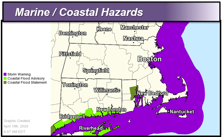
Good morning everyone, Here are our latest thoughts on the potential for damaging wind gusts and heavy downpours today leading to some urban flooding potential. The greatest time of concern is late this morning into early evening. *Changes since the last update:* - Increased emphasis on chance for urban and poor drainage flooding in heavy downpours. Some small streams may approach Action Stage. - Added a Coastal Flood Statement for upper parts of Narragansett Bay including the city of Providence for the low risk of minor coastal flooding during today's mid day high tide *Headlines:* - *High Wind Warning *for all of southern New England except Franklin County Massachusetts from midday until early tonight. - *Wind Advisory* for Franklin County Massachusetts from midday until early tonight. - *Storm Warning *in effect for the ocean waters from this morning into this evening - *Coastal Flood Statement *in effect for upper portions of Narragansett Bay for the mid day high tide *Damaging Winds:* Southerly wind gusts of 55 to 70 mph are possible late this morning through this evening, with sustained winds of 20-40 mph. The highest winds are expected across Rhode Island and southeast Massachusetts including Cape Cod and the Islands, but damaging wind gusts are possible across all of southern New England. *Heavy Rain:* Rainfall amounts of 1 to 2 inches are possible from early Monday morning through Monday early Monday night. Isolated amounts up to 3 inches are possible, especially where where any thunderstorms move through. *Thunderstorms**:* There is a low risk of an isolated thunderstorm this afternoon and early tonight, mainly for western CT and MA. Some of these storms could become severe bringing damaging winds. *Impacts:* - Scattered to widespread power outages are possible due to downed trees, tree limbs and power lines. Difficult travel for high profile vehicles. - Heavy rain may cause brief localized urban and poor drainage flooding. *Uncertainty:* - We are confident in strong to damaging wind gusts, but the area of highest wind gusts is less certain. As of right now, the most likely areas are across northern CT, northern and central RI, and interior southeast MA including the city of Boston. Thank you Bryce Williams and Frank Nocera If you have any questions or would like more information, don't hesitate to contact us via this email address, on NWSChat <https://nwschat.weather.gov/>, or at the following: National Weather Service Boston/Norton, MA 46 Commerce Way Norton, MA 02766 508.622.3280 Website <http://www.weather.gov/boston> | Facebook <http://www.facebook.com/NWSBoston> | Twitter <http://www.twitter.com/NWSBoston>
participants (1)
-
 BOX Operations - NOAA Service Account