[2019.02.10 PM] Snow / Sleet / Freezing Rain ... Significant Impacts for the Tuesday PM Commute

Good afternoon, Little has changed from the previous forecast, but we have issued Winter Storm Watches for western, central, and parts of eastern Massachusetts. Please see the attached slides conveying the anticipated threats while details concerning impacts and uncertainty are provided below. Please note, the timing of precip type graphic is an animation. *New Headlines ...* - *WINTER STORM WATCH* issued for western, central, and parts of eastern Massachusetts from Tuesday afternoon to Wednesday morning. *What / Where / When ... * - Onset snow transitioning to a wintry mix of mostly sleet with some freezing rain across interior Southern New England, transitioning to rain along the coast late Tuesday night. - Beginning Tuesday afternoon, ending by early to mid-morning Wednesday. - Biggest concern are the impacts for the Tuesday afternoon into evening commute. - Hazardous travel conditions on roads, especially untreated surfaces, and reductions in visibility as a result of potential high snowfall rates. *Uncertainty ... * - Still some uncertainty with timing, best scenario would be a later onset of snowfall across eastern Massachusetts until after the evening commute. The rest of the region looks to be impacted regardless. - Potential for snowfall rates of 1-2" an hour during the evening commute. - Snow and ice amounts could differ across the interior depending on how fast warm air moves in overnight. - Wednesday morning commute should be okay for the majority of the region, but there could still be some lingering icy spots across the interior. We will continue to issue briefings leading up to the event with the latest forecast information. Should you have any questions, comments and/or concerns, please don't hesitate to reach out to us. Thank you, NWS Boston If you have any questions or would like more information, don't hesitate to contact us via this email address, on NWSChat <https://nwschat.weather.gov/>, or at the following: National Weather Service Boston/Norton, MA 46 Commerce Way Norton, MA 02766 508.622.3280 Website <http://www.weather.gov/boston> | Facebook <http://www.facebook.com/NWSBoston> | Twitter <http://www.twitter.com/NWSBoston>
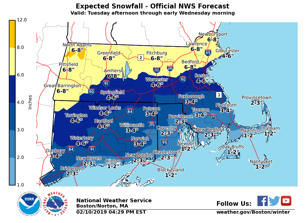
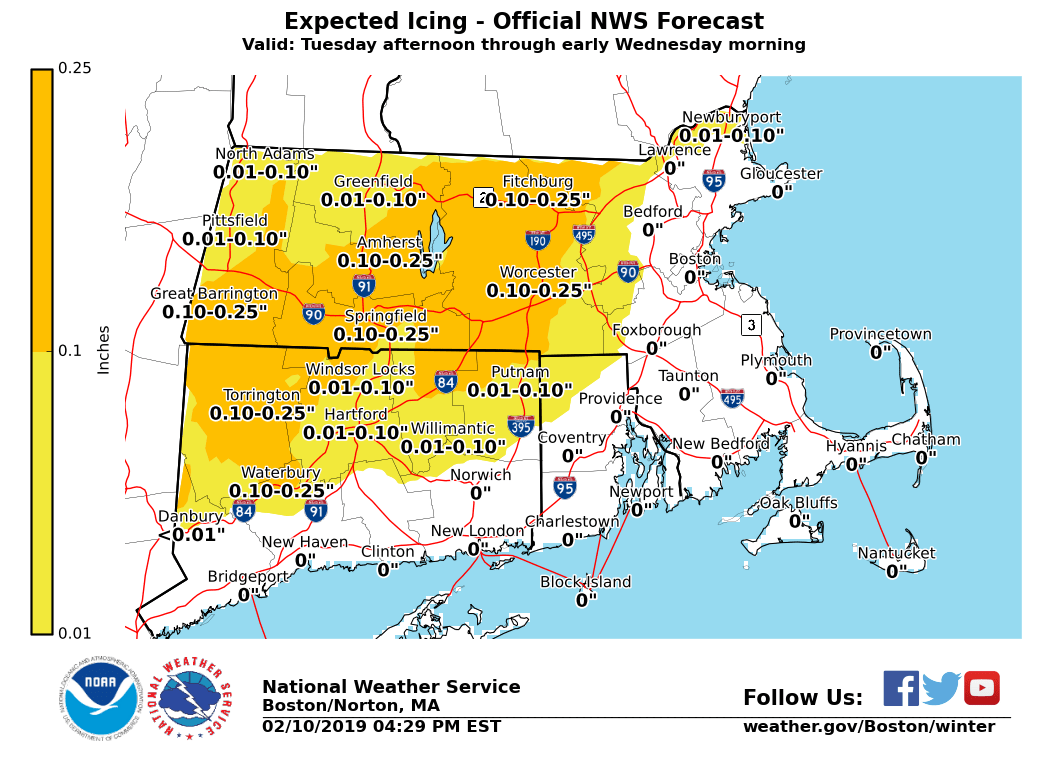
Good afternoon, Our apologies but the dates on the snow and ice graphics should say Tuesday afternoon through early Wednesday morning. Attached are the graphics with the correct dates. Thank you, NWS Boston If you have any questions or would like more information, don't hesitate to contact us via this email address, on NWSChat <https://nwschat.weather.gov/>, or at the following: National Weather Service Boston/Norton, MA 46 Commerce Way Norton, MA 02766 508.622.3280 Website <http://www.weather.gov/boston> | Facebook <http://www.facebook.com/NWSBoston> | Twitter <http://www.twitter.com/NWSBoston> On Sun, Feb 10, 2019 at 4:00 PM BOX Operations - NOAA Service Account < box.operations@noaa.gov> wrote:
Good afternoon,
Little has changed from the previous forecast, but we have issued Winter Storm Watches for western, central, and parts of eastern Massachusetts.
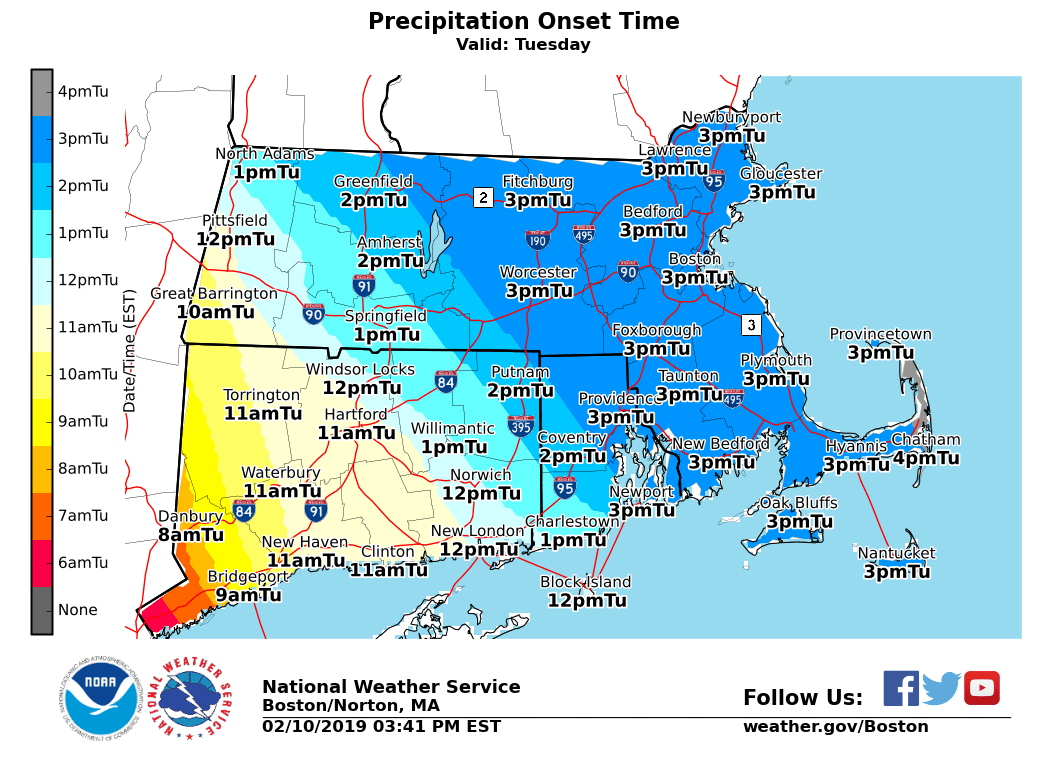
Please see the attached slides conveying the anticipated threats while details concerning impacts and uncertainty are provided below. Please note, the timing of precip type graphic is an animation.
*New Headlines ...*
- *WINTER STORM WATCH* issued for western, central, and parts of eastern Massachusetts from Tuesday afternoon to Wednesday morning.
*What / Where / When ... *
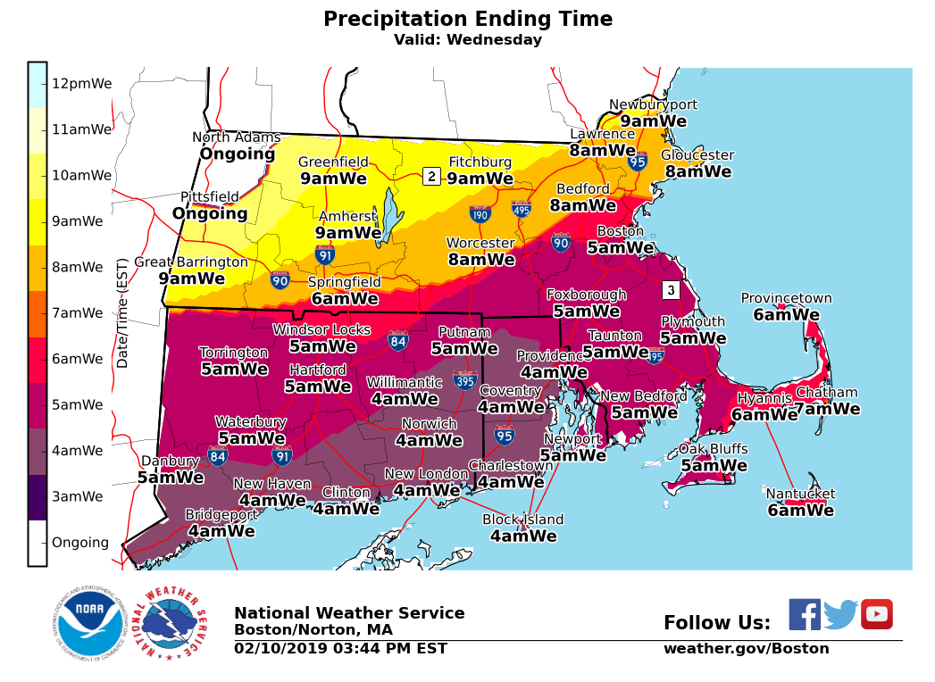
- Onset snow transitioning to a wintry mix of mostly sleet with some freezing rain across interior Southern New England, transitioning to rain along the coast late Tuesday night. - Beginning Tuesday afternoon, ending by early to mid-morning Wednesday. - Biggest concern are the impacts for the Tuesday afternoon into evening commute. - Hazardous travel conditions on roads, especially untreated surfaces, and reductions in visibility as a result of potential high snowfall rates.
*Uncertainty ... *
- Still some uncertainty with timing, best scenario would be a later onset of snowfall across eastern Massachusetts until after the evening commute. The rest of the region looks to be impacted regardless. - Potential for snowfall rates of 1-2" an hour during the evening commute. - Snow and ice amounts could differ across the interior depending on how fast warm air moves in overnight. - Wednesday morning commute should be okay for the majority of the region, but there could still be some lingering icy spots across the interior.
We will continue to issue briefings leading up to the event with the latest forecast information. Should you have any questions, comments and/or concerns, please don't hesitate to reach out to us.
Thank you, NWS Boston
If you have any questions or would like more information, don't hesitate to contact us via this email address, on NWSChat <https://nwschat.weather.gov/>, or at the following:
National Weather Service Boston/Norton, MA 46 Commerce Way Norton, MA 02766 508.622.3280 Website <http://www.weather.gov/boston> | Facebook <http://www.facebook.com/NWSBoston> | Twitter <http://www.twitter.com/NWSBoston>
participants (1)
-
 BOX Operations - NOAA Service Account