NWS Boston EM Briefing: Potential Weather Hazards Through This Weekend

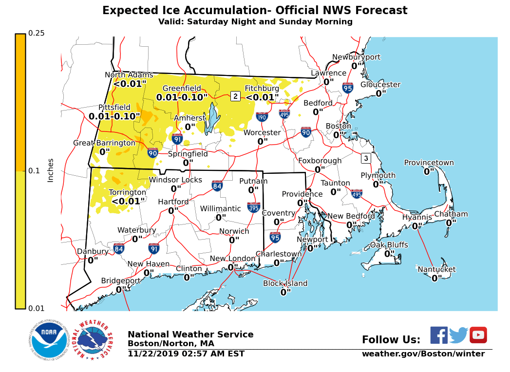
Good Morning, We are monitoring two weather systems through the weekend for possible hazardous weather: *This Afternoon and Tonight:* A strong cold front will cross the region this afternoon, followed by strong west winds this afternoon and tonight, which will mainly affect the marine community. *Marine Impacts: Gale Force Winds* *Locations*: Massachusetts and Rhode Island coastal waters *Timing:* Onset of Gales between 3 and 6 PM, ending between 3 and 6 AM Saturday, except by 11 AM farther offshore. *Wind Gusts:* W 35 to 40 knots, peaking between 8 PM and 2 AM. *Seas:* 4 to 7 feet on the inner bays and sounds; 10 to 15 ft offshore. *Impact:* Hazardous conditions for mariners. *Uncertainty:* Low. *Saturday Night and Sunday:* Low pressure is expected to track near Nantucket. As rain overspreads the region Saturday night, it will be cold enough for a wintry mix across parts of the interior with the potential for light icing and impacts to travel. Milder air will cause a change to rain Sunday morning. *Interior Light Icing (See Attached Image):* *Locations*: Western and north-central Massachusetts, possibly northwest Hartford County, CT, especially in the higher elevations. *Timing:* Wintry mix of snow and light freezing rain late Saturday night into early Sunday morning, changing to rain by late morning or early afternoon. *Impact*: Slippery travel. *Uncertainty:* Timing of the exact changeover. Higher confidence that snow and ice amounts will be light, with up to an inch of snow and a light coating (up to 1/10") of ice. *Minor Coastal Flooding: Sunday Morning High Tide* *Locations*: Eastern Massachusetts coast (including Martha's Vineyard and Nantucket) and the South Coast *Timing:* Sunday morning high tide (5:41 AM at Providence, 8:45 AM at Boston, and 9:46 AM on Nantucket) *Storm Surge:* 1.0 to 1.5 feet *Inundation:* Less than 1 foot above ground level *Impact*: Some vulnerable shoreline roads may become temporarily impassable around high tide. *Uncertainty:* High. Timing of highest surge may not coincide with high tide, which would lead to little or no impact. Minor coastal flooding would be the worst case scenario. *Minor Coastal Flooding: Sunday Evening High Tide* *Locations*: Eastern Massachusetts coast including Martha's Vineyard and Nantucket *Timing:* Sunday evening high tide (9:17 PM at Boston and 10:24 PM on Nantucket) *Storm Surge:* Around 2.0 feet *Inundation:* Up to 1 foot above ground level *Impact*: Some vulnerable shoreline roads may become temporarily impassable around high tide. *Uncertainty:* Lower than with the morning high tide. Locations along the Bay side of Cape Cod, Plymouth County, and Nantucket are most vulnerable. Updates will be sent as needed. If you have any questions or would like more information, don't hesitate to contact us via this email address, on NWSChat <https://nwschat.weather.gov/>, or at the following: National Weather Service Boston/Norton, MA 46 Commerce Way Norton, MA 02766 508.622.3280 Website <http://www.weather.gov/boston> | Facebook <http://www.facebook.com/NWSBoston> | Twitter <http://www.twitter.com/NWSBoston> Thanks, Joe DelliCarpini and Andrew Loconto
participants (1)
-
 BOX Operations - NOAA Service Account