[2019.12.14 PM] NWS Boston EM Briefing: Strong Winds & River Rise thru Sun, Wintry Weather Mon Night - Tue

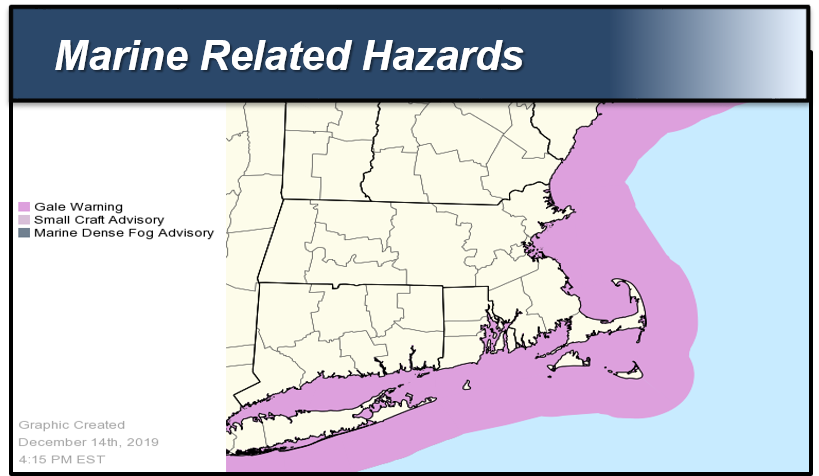
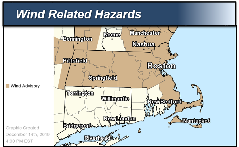
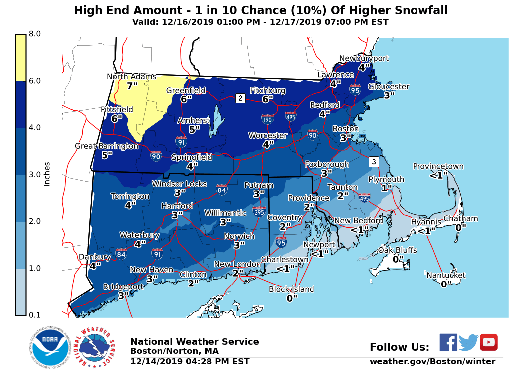
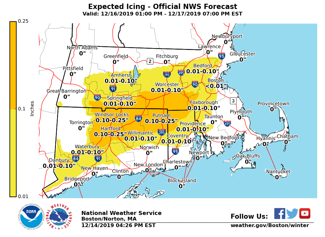
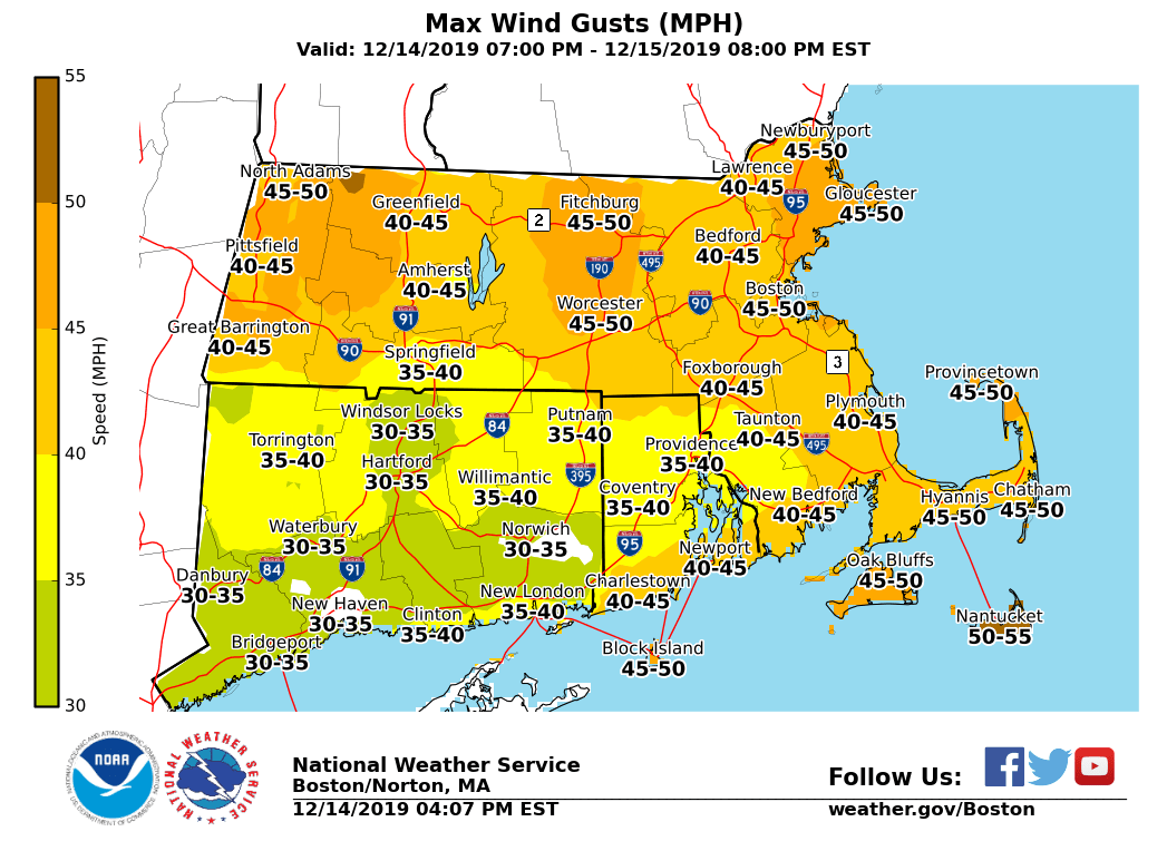
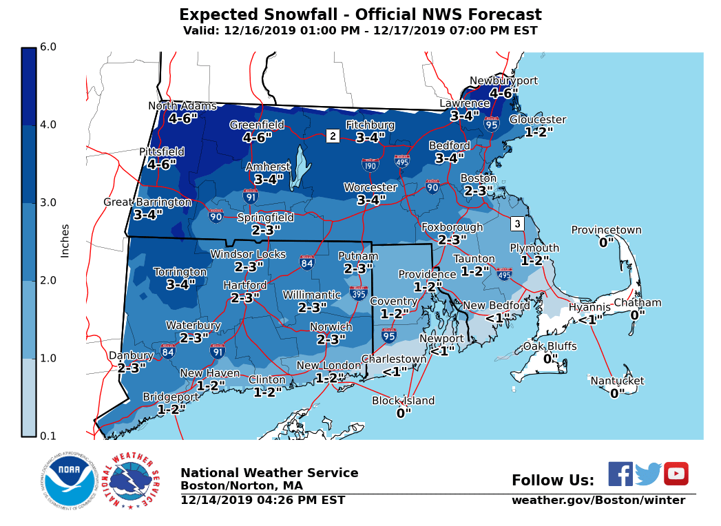
Good evening, Following is an update on river rises, strong winds and high seas through Sunday. However, we also want to provide a heads-up on another round of accumulating wintry weather for Monday night into Tuesday. *Changes with this update:* - *Wind Advisory issued:* Much of MA (except Bristol County) and Block Island. In Effect from 1 AM to 9 PM Sunday. - Updated snow and ice accumulations for Monday Night into Tuesday. *River Rises, Strong Winds and Rough Seas: Tonight through Sunday* *River Rises/Minor Flooding:* *Locations*: Mainly the Pawcatuck River at Westerly and Wood River Junction, Pawtucket River at Cranston, Wood River at Hope Valley, the Willimantic River at Coventry and the Taunton River at Bridgewater. *Timing*: Through Sunday afternoon. *Impact*: Rivers rising to near or over minor flood stage. Receding trends through Sunday afternoon. *Confidence*: Moderate to High. *Strong Winds:* *Locations*: Most of MA except Bristol County, and for Block Island in RI. *Timing*: Overnight into Sunday. Strongest winds Sunday late morning to afternoon. *Wind Speeds*: W to NW winds 20 to 30 mph with gusts 45-50 mph. *Impact*: Gusty winds could blow unsecured objects around. Tree limbs could be blown down and a few power outages may result. *Confidence*: High. *High Seas: * *Locations*: Coastal waters from Provincetown to Chatham to Nantucket and out 20 nm, Coastal waters 25nm south of Martha's Vineyard and Nantucket. *Timing*: Through 7 PM Sunday. *Wave Heights*: 10 to 15 feet. *Impact*: Hazardous seas combined with strong winds could capsize or damage vessels. *Confidence*: High Attached supporting graphics include the active Wind and Marine Headlines in effect, as well as the maximum wind gust forecast in MPH. *Accumulating Snow to Wintry Mix: Monday Night into Tuesday* We are also monitoring a period of wintry weather for Monday night into Tuesday. There is increased confidence that Monday overnight into the Tuesday AM commute will be impacted by snow and/or ice-covered roads with potential for travel difficulties. Initial snow to change to mixed precipitation across interior MA, northern CT into RI overnight into Tuesday. While most of the interior will stay wintry, a shorter period of snow and/or mixed precipitation is currently anticipated for E and SE MA into coastal RI, with an earlier transition to rain as temperatures warm above freezing sooner. *Confidence:* Moderate to high on wintry weather impacting the Tuesday AM commute, though only moderate confidence in snow and ice accumulations. Precipitation type changeovers and timing the changeovers remains uncertain and could alter snow and/or ice accumulations. Steadier bands of snow with snow rates at or over an inch per hour could result overnight into early Tuesday AM, though it is not clear where these bands may set up. Attached are supporting graphics for this event, with updated snow and ice accumulation forecasts. A reasonable worst-case snowfall accumulation is also attached, which may materialize if heavier snow bands were to transpire and/or if less mixed wintry precip is expected. Meteorologist: Andrew Loconto If you have any questions or would like more information, don't hesitate to contact us via this email address, on NWSChat <https://nwschat.weather.gov/>, or at the following: National Weather Service Boston/Norton, MA 46 Commerce Way Norton, MA 02766 508.622.3280 Website <http://www.weather.gov/boston> | Facebook <http://www.facebook.com/NWSBoston> | Twitter <http://www.twitter.com/NWSBoston>
participants (1)
-
 BOX Operations - NOAA Service Account