[2019.02.17 Briefing #4] Updated Afternoon Briefing On Plow-able Snow Late Tonight Into Monday Afternoon

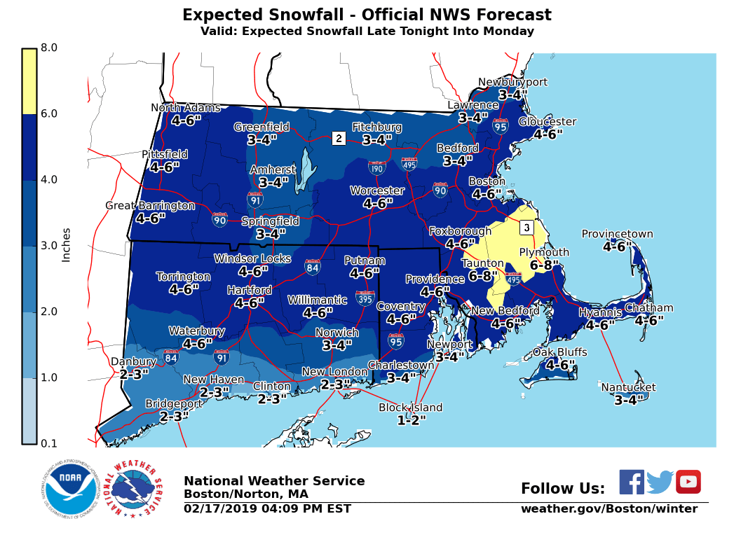
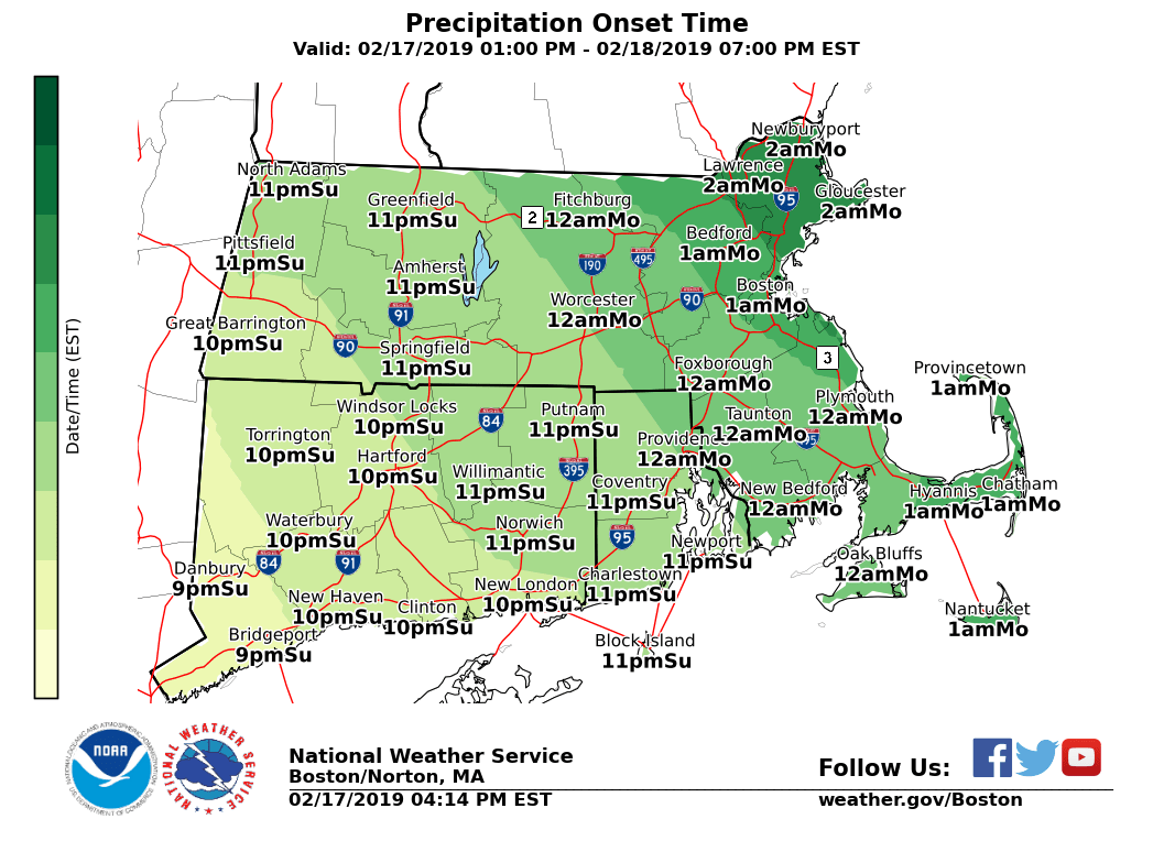
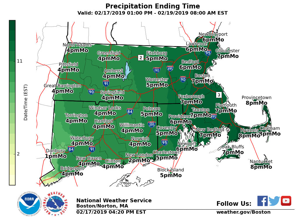
Good afternoon everyone. We have included a brief outline in this email and attached the latest snowfall forecast along with the approximate start and end times. *What has changed:* - Winter Storm Warnings Issued for northern Rhode Island into portions of southeast MA approaching the Cape Cod Canal. 4 to 7 inches of snow expected. - Winter Weather Advisories expanded to include the rest of southern New England for a general 3 to 6 inches of snow. *WHAT: * - A plow-able snowfall is in store for the region. *WHERE: * - All of Massachusetts, Rhode Island and Connecticut *WHEN: * - Snow is expected to overspread the region from southwest to northeast between 9 pm and 2 am Monday morning. - The heaviest snow will fall after midnight through about 9 am Monday morning near and especially south of the Massachusetts turnpike. - Lighter snows will continue later Monday morning and afternoon, but bands of heavier snow will impact central and eastern Massachusetts at times. *POTENTIAL IMPACTS:* - Roads will become snow covered/slippery along with reduced visibility for the Monday morning commute particularly near and especially south of the MA turnpike (although more limited given the Holiday). - Greatest risk for snow and slippery roads during the Monday afternoon/early evening commute will be across central and eastern MA, where the ending time will be the latest. *UNCERTAINTY:* - High confidence in a general 3 to 7 inches of snow across the region. Greatest risk for higher amounts will be across portions of RI into southeast MA. - If the low tracks further south amounts will be on the lower end of those numbers, while if it ends up a bit further north snow amounts will be on the higher end. - Snow amounts on the immediate south coast, Cape and Islands are subject to change by a few inches dependent on how far north the rain/sleet line gets into the region. Please let us know if you have any questions or concerns. Thank You Meteorologist: Hayden Frank If you have any questions or would like more information, don't hesitate to contact us via this email address, on NWSChat <https://nwschat.weather.gov/>, or at the following: National Weather Service Boston/Norton, MA 46 Commerce Way Norton, MA 02766 508.622.3280 Website <http://www.weather.gov/boston> | Facebook <http://www.facebook.com/NWSBoston> | Twitter <http://www.twitter.com/NWSBoston>
participants (1)
-
 BOX Operations - NOAA Service Account