
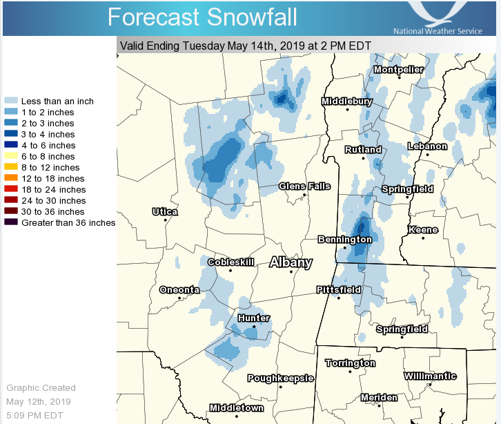
**** The information in this email pertains to the following areas only:**** *- In Massachusetts: Berkshire County* *- In Vermont: Bennington & Windham Counties* *- In New York: Albany, Columbia, Dutchess, Fulton, Hamilton, Herkimer, Montgomery, Greene, Rensselaer, Saratoga, Schenectady, Schoharie, Ulster, Warren and Washington Counties* Dear Emergency Managers and other partners, Periods of rain Monday will likely mix with or change to wet snow over higher elevations in the Catskills, Helderbergs, Taconics, Berkshires, Green and Adirondack mountains Monday night and Tuesday morning. An inch or two of snow may accumulate above 1000 feet mainly on grassy surfaces or elevated surfaces such as tree limbs by mid-morning Tuesday. As much as 4 inches of snow could accumulate over the highest elevations above 2000 feet. If you have any questions, please feel free to contact us via: 1. Email: alb.stormreport@noaa.gov 2. NWSChat at https://nwschat.weather.gov/live/ 3. Social Media: Facebook <https://www.facebook.com/NWSAlbany> and Twitter <https://twitter.com/NWSAlbany> 4. Telephone: (518) 435-9575 <518-435-9575> Sincerely, NWS Albany www.weather.gov/albany