
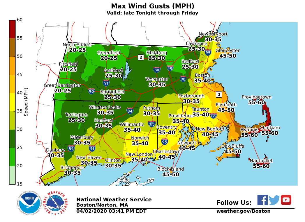
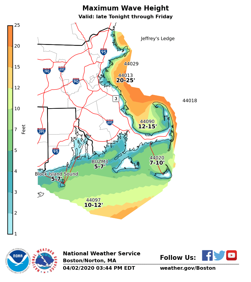
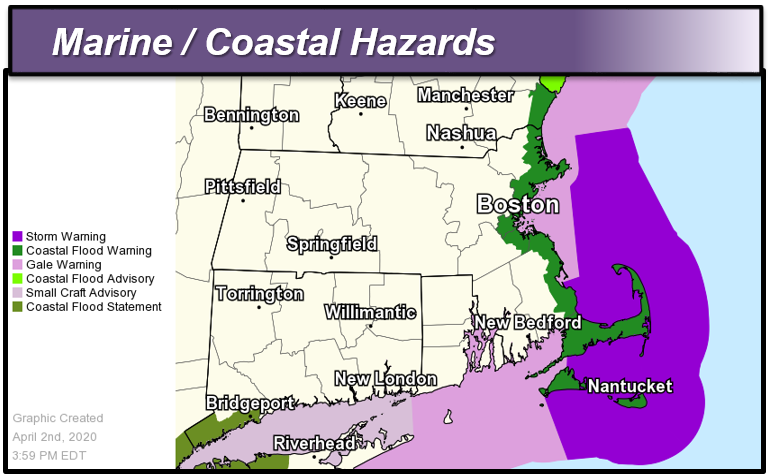
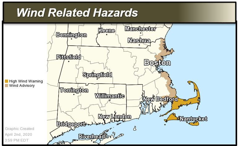
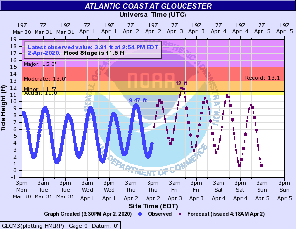
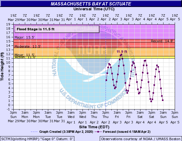
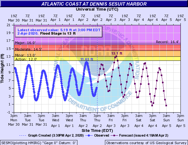
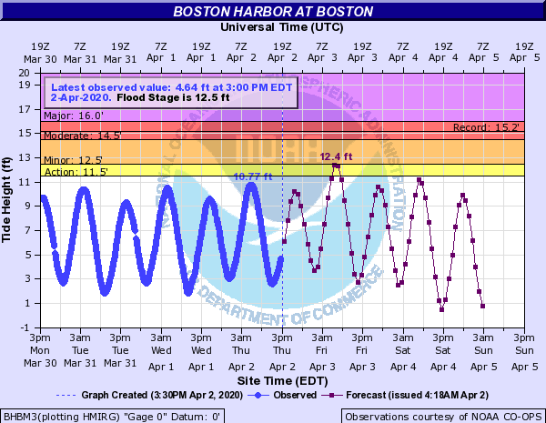
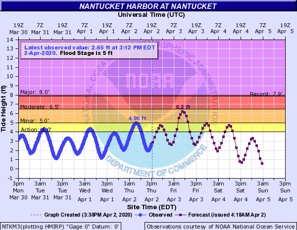
Good afternoon, We continue to track a strong ocean storm southeast of Cape Cod which will push west tonight before moving further offshore on Friday. This storm will bring strong to damaging winds and increasing rough seas with minor to moderate coastal flooding during Friday morning's high tide. With the expected increase of the wind and seas across eastern areas, all advisories have been upgraded to warnings for tomorrow morning's high tide. Details are below. *Headlines:* - High Wind Warning*: *In effect from early Friday morning through Friday evening for Cape Cod, Nantucket and Martha's Vineyard. - *Wind Advisory*: In effect from early Friday morning through Friday evening for Cape Ann as well as eastern and southern Plymouth county - *Coastal Flood Warning*: In effect for Friday morning's high tide for all of the east coast of MA, including Nantucket and Martha's Vineyard - *Coastal Flood Advisory*: In effect for this evening's high tide for Nantucket Harbor. - Storm Warning: In effect early Friday morning thru Friday evening, for the coastal waters east of Ipswich Bay and Stellwagen Bank National Marine Sanctuary and the offshore waters adjacent Cape Cod and the Islands (excluding Buzzards Bay and Vineyard Sound). - *Gale Warning*: In effect early Friday morning thru Friday evening, for the remaining waters. *Details:* *Coastal Flooding: * *This evening: Minor coastal flooding expected at Nantucket Harbor for this evening's high tide. * *Friday Morning: Widespread Minor with pockets of moderate coastal flooding* - *Locations*: East coastal Mass, Cape Cod and the Islands. - *Timing*: From 6 AM to 10 AM Friday morning. - *Impacts/Inundation*: For Nantucket: One to two feet of inundation above ground level possible. For east coastal Mass including Cape Cod and Martha's Vineyard, up to one foot of inundation above ground level is possible. - *Confidence and Uncertainty: *High confidence on coastal flooding, greatest confidence for minor structural damage for Nantucket. A storm track closer to the southern New England coast may further elevate the coastal flood threat. *Strong to Damaging Winds: * - *Locations: *Cape Cod, the Islands and east coastal Mass. - *Timing: *Northeast winds increase late tonight, with peak gusts Friday morning thru afternoon. - *Winds*: Northeast wind gusts up to 60 mph for Cape Cod and the islands, and up to 50 mph for east coastal Mass. - *Impacts: *Possible downed trees and power lines. - *Confidence and Uncertainty*: Moderate to high confidence on gusts producing minor to moderate impacts across Cape Cod and the Islands. A closer storm track to coastal southern New England would expand the coverage of stronger northeast winds further inland. In that situation, strong winds capable of minor tree/powerline damage could be possible as far west as I-95. Thank you, Bryce Williams, Bill Babcock, and Bill Leatham If you have any questions or would like more information, don't hesitate to contact us via this email address, on NWSChat <https://nwschat.weather.gov/>, or at the following: National Weather Service Boston/Norton, MA 46 Commerce Way Norton, MA 02766 508.622.3280 Website <http://www.weather.gov/boston> | Facebook <http://www.facebook.com/NWSBoston> | Twitter <http://www.twitter.com/NWSBoston>