
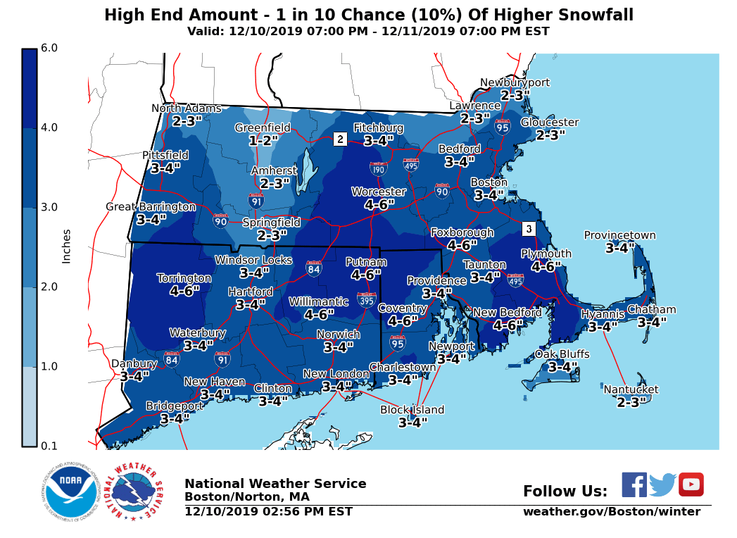
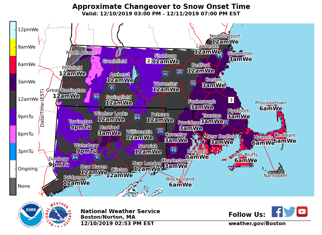
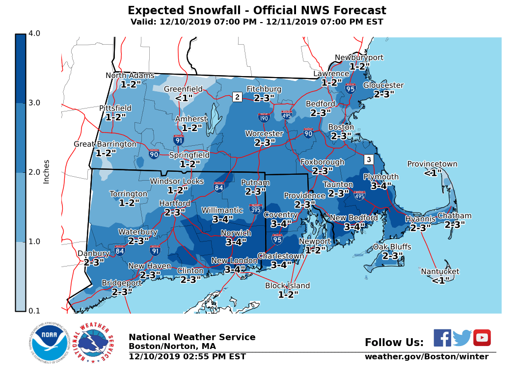
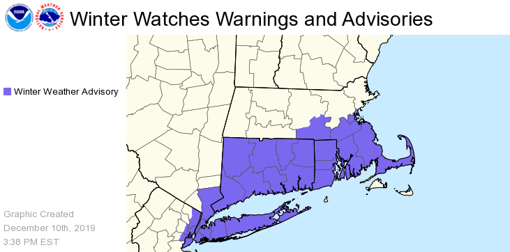
Good afternoon, Following is an updated briefing on the expected changeover from rain to accumulating snow expected to affect parts of southern New England late tonight into the first part of Wednesday. *Changes with this update:* - Minor adjustments to start time and storm total accumulations. *No changes to headlines.* *What To Expect and When: * - Rain will change to snow from NW to SE late tonight into early Wednesday. The attached Onset graphic provides an approximate start time to the changeover to snow. - Steady light snows are expected to fall across most of southern New England into Wednesday, but steadier moderate-intensity snows are possible towards eastern CT, RI, SE Mass into Cape Cod by the Wednesday AM commute. - Snow is expected to decrease in intensity through noontime before ending across the South Coast by Wednesday early afternoon. *Accumulations:* A general inch to 4 inches, greatest amounts south/east. While less likely, a reasonable worst-case snowfall accumulation is attached. This gives a sense of what may happen if the axis of heaviest snows shifts N/W and/or if narrow bands were to organize. *Impacts: * - Wet pavement from recent rains may freeze before or during the period of snow, resulting in slick roads. - Snow may be enough to shovel and plow by Wednesday morning, especially areas S/E of I-95. - Difficult travel for the Wednesday morning commute. *Forecast Confidence: *Moderate to high. The band of heaviest snow accumulations may shift N/W toward a larger part of the I-95 corridor S of Boston. Snow may organize into narrow bands that could result in heavier snowfall rates; where these bands set up is not clear. Attached graphics include the current Hazards in effect, an Onset graphic which shows approximately when rain may change to snow, the updated official storm total snow forecast, and a reasonable worst-case snow accumulation forecast. Meteorologist: Andrew Loconto If you have any questions or would like more information, don't hesitate to contact us via this email address, on NWSChat <https://nwschat.weather.gov/>, or at the following: National Weather Service Boston/Norton, MA 46 Commerce Way Norton, MA 02766 508.622.3280 Website <http://www.weather.gov/boston> | Facebook <http://www.facebook.com/NWSBoston> | Twitter <http://www.twitter.com/NWSBoston>