
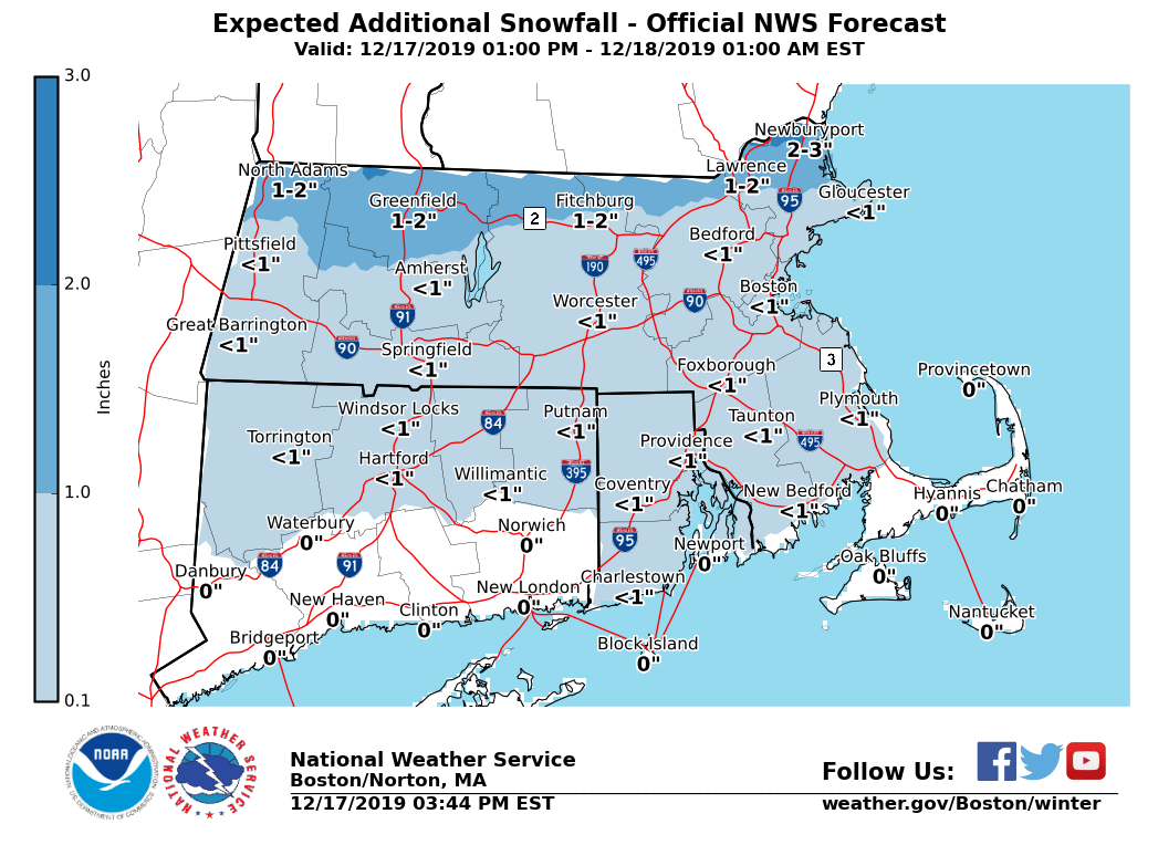
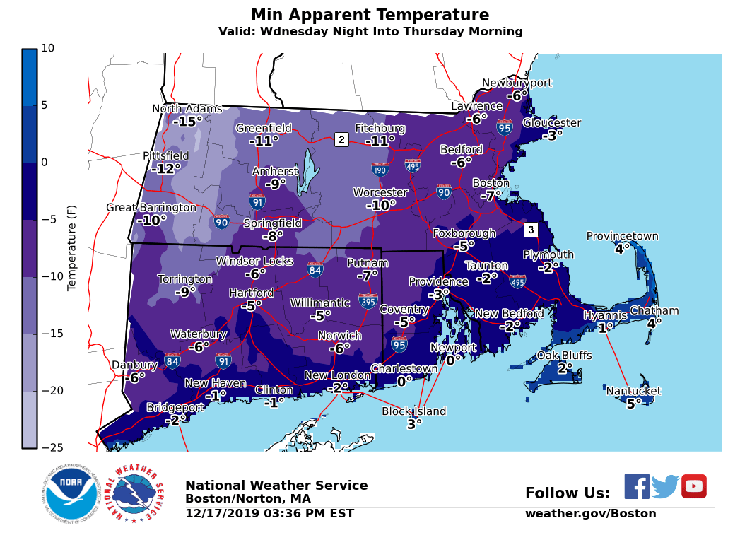
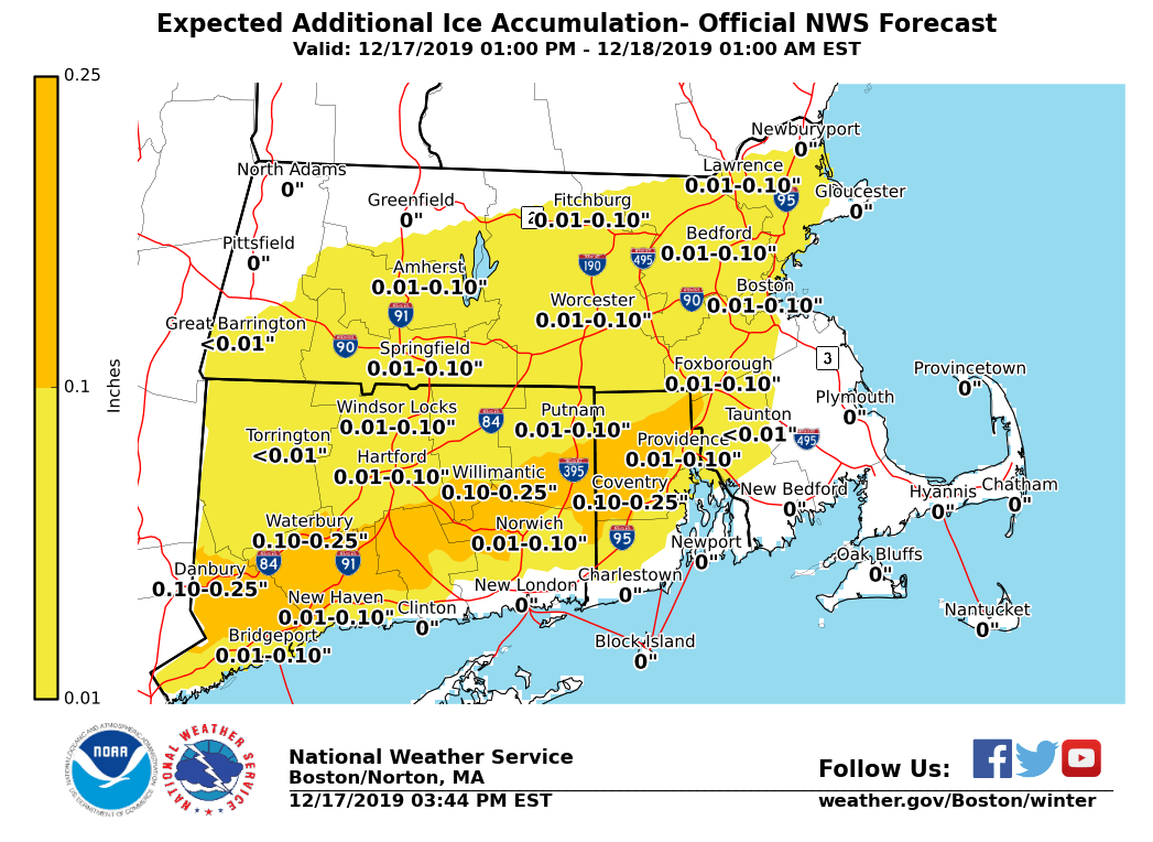
Good afternoon everyone, Here is the latest briefing for this evening, possible snow squalls Wednesday afternoon and evening, as well as the arctic blast Wednesday night into Thursday. *What Has Changed:* - Winter Weather Advisories extended until 9 PM this evening *Additional A**ccumulating Snow and Light To Moderate Ice Accretion:* *Locations*: South of Route 2 in northern MA. *Timin*g: Mixed precipitation. *Amounts*: Up to 1 inch of additional snow accumulation, with up to one tenth inch of additional ice accretion. Icing most likely across northern CT, northern RI and southern MA into Metrowest. *Impact*: Snow and ice will result in hazardous travel for the evening commute. Untreated surfaces will be slippery. *Confidence*: High confidence in mixed precipitation. Moderate confidence in timing for individual precipitation types at any given location. *Locations*: North of Route 2 in northern MA. *Timin*g: Mainly snow, with periods of sleet and freezing rain at times. Rain towards the immediate east coast of MA. *Amounts*: 1 to 2 inches of additional snow/sleet. A trace to less than one tenth inch of additional ice accretion, mainly near the Mass Pike and Middlesex County. *Impact*: Snow and ice will result in hazardous travel for the evening commute. Untreated surfaces will be slippery. *Confidence*: High confidence in mixed precipitation. Moderate confidence in timing for individual precipitation types at any given location. *Isolated to Scattered Snow Squalls:* *Locations*: All locations. *Timing*: Wednesday afternoon into early evening. *Amounts*: A quick coating to half an inch in less than 30 minutes. *Impact*: Temporarily reduced visibility could catch drivers off guard, especially for early evening commute. Also, roads could become snow-covered quickly, resulting in slippery travel. *Confidence*: Low to moderate. Areal extent of snow squalls will be limited with many locations likely remaining dry. Best chance of snow squalls will be in the interior. *Bitter Cold/Very Low Wind Chills:* *Locations*: All locations. *Timing*: Wednesday night into Thursday morning. *Amounts*: Wind chill values -5 to -20°F across the interior, and zero to -5°F across eastern MA and RI. *Impact*: Coldest air of the season. Bitter cold wind chills for school bus stops. *Confidence*: High. Wind Chill Advisories may be issued with later forecasts. *Potential risk of freezing spray:* *Locations*: Immediate coastal waters off Eastern MA and RI. *Timing*: Wednesday night into early Thursday morning. *Amounts*: Light to moderate freezing spray possible. *Impact*: Glaze of ice possible on boats and ships traversing the waters. *Confidence*: Moderate overall, highest risk across the nearshore waters. Matthew Belk If you have any questions or would like more information, don't hesitate to contact us via this email address, on NWSChat <https://nwschat.weather.gov/>, or at the following: National Weather Service Boston/Norton, MA 46 Commerce Way Norton, MA 02766 508.622.3280 Website <http://www.weather.gov/boston> | Facebook <http://www.facebook.com/NWSBoston> | Twitter <http://www.twitter.com/NWSBoston>