
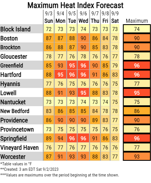
Good morning, We wanted to provide you with an update on the weather forecast, especially for the upcoming week. As mentioned in our previous email, it appears that we are in for a return of summertime heat in the early to mid-part of next week. While there hasn't been significant change in the forecast, our confidence in this is increasing. Afternoon temperatures are expected to climb back into the middle and upper 80s, with isolated areas possibly reaching the lower 90s. Alongside this, we anticipate rising dewpoint temperatures and elevated relative humidity levels, which will make it feel like temperatures are in the low to mid-90s on Monday, Tuesday, and Wednesday. We kindly request that you continue to monitor your emails over the weekend for any further updates. While no official advisories have been issued at this time, it's not beyond the realm of possibility that a Heat Advisory may become necessary for select areas of southern New England. Attached below, you will find the maximum heat index forecast, indicating the highest expected heat index values. For your reference, here are the criteria for a Heat Advisory: - Daytime heat indices of 95°F to 99°F for two or more hours over two consecutive days, or - 100°F to 104°F for two or more hours over one day. We will issue another update email by 5:00 AM on Sunday to keep you informed about any developments. Thank you for your continued attention to this matter, Torry Dooley and Andrew Loconto If you have any questions or would like more information, please don't hesitate to contact us. You can reach us via: email: box.operations@noaa.gov phone: 508.622.3280 Slack/NWSChat 2.0 <https://nwschatws.slack.com/> (for approved partners) social media: Website <http://www.weather.gov/boston> | Facebook <http://www.facebook.com/NWSBoston> | Twitter <http://www.twitter.com/NWSBoston>