
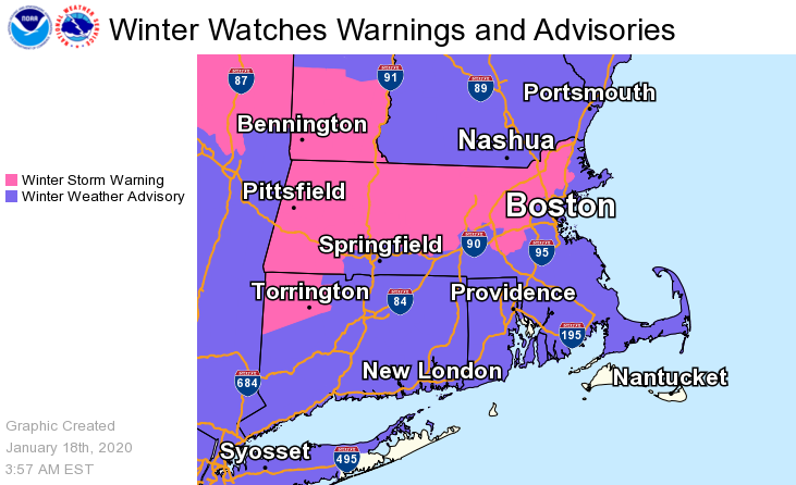
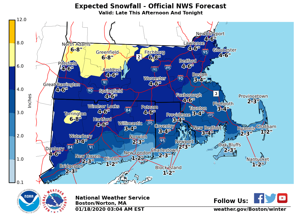
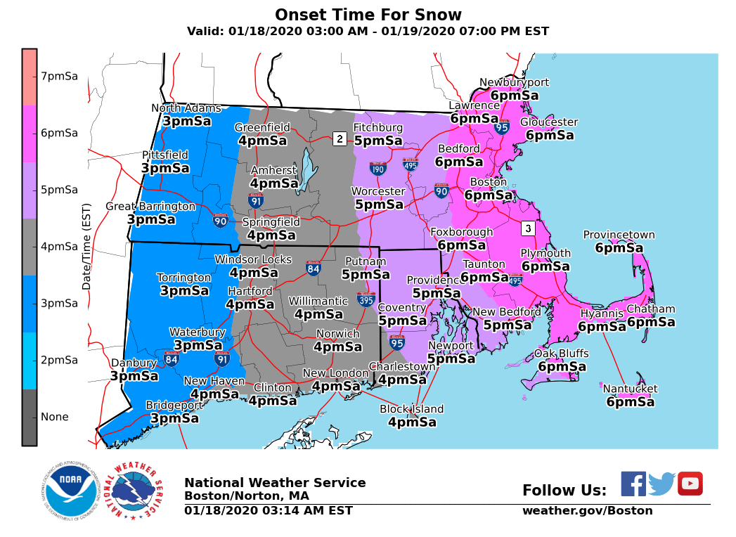
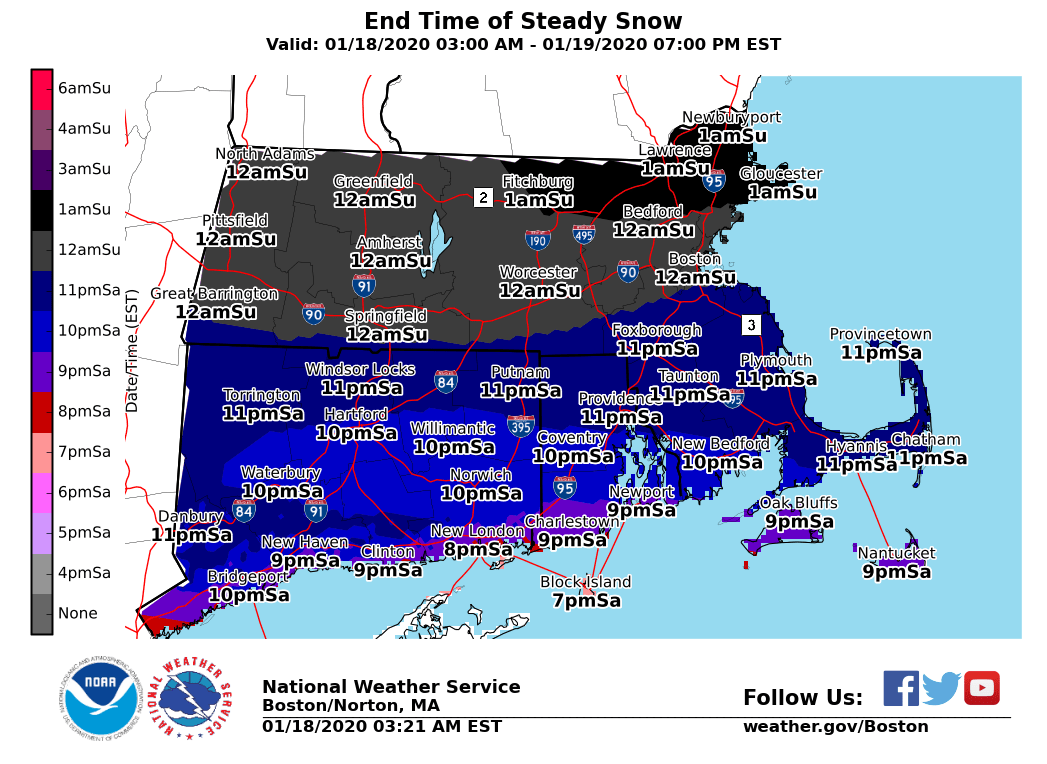
Good morning everyone, Very little change made to the forecast early this morning, but we did extend the Winter Weather Advisory further south onto the south coasts of RI & MA including Cape Cod. Please see the outline below for more details. We also have attached the approximate start/stop times of the steady snow along with the expected amounts. *What has changed ...* - *Winter Weather Advisories* extended into south coastal MA and RI including Cape Cod, where 2-4" of snow is expected before changing over to rain before ending. - The rest of the forecast is unchanged with Winter Storm Warnings/Advisories In Effect for 3 to 7 inches of snow with highest amounts expected in western/northern MA. Up to 8 inches of snow is possible in parts of the northwest Berkshires. *Timing ... * - Snow overspreads western MA and northern CT around 3 or 4 PM and reaching eastern MA by 5 or 6 PM. - Bulk of the accumulating snow begins to taper off between 10 pm and 1 am from west to east. *Duration ... * - This is a fast moving system so the snow will be limited to roughly a 3-6 hour window, but will fall moderate to perhaps briefly heavy for a short time. - Here is an approximate timeline of the steadiest snow/precip - * Boston:* 6pm to midnight,* Worcester to Springfield *5 pm to 11 pm, *Providence *6 pm to 10 pm,* Hartford* 5 pm to 10 pm. *Impacts ...* - Not a block buster snow event but it will snow moderate to briefly heavy for a 3-6 hour window (times above) with snowfall rates up to an inch per hour possible during this time. - Cold roads will become snow-covered and slippery immediately after the snow commences. Travel will be difficult this evening with poor visibility too, but improvement expected after midnight. *Snow Totals ... * - Most of MA, RI & CT will receive a quick 3 to 7 inches of snow. Higher amounts towards western and northern MA with the lower amounts near the south coast and Cape. - Snow will end as light rain or drizzle towards midnight across RI/SE MA with temps rising above freezing. - Snow may ends as a period of light freezing drizzle across portions of interior MA and CT towards midnight. Little additional impact expected from that with that falling on top of the earlier snow. *Forecast Confidence ... * - High confidence in several inches of snow falling late today and this evening. - High confidence that snow sticks to roadways immediately with cold ground temperatures. - Localized snow banding may result in some locations getting 1 to 2 inches more or less than what is currently expected, but overall this is a rather high confident forecast. An additional email will be sent late this afternoon. Thank You Meteorologist: Hayden Frank If you have any questions or would like more information, don't hesitate to contact us via this email address, on NWSChat <https://nwschat.weather.gov/>, or at the following: National Weather Service Boston/Norton, MA 46 Commerce Way Norton, MA 02766 508.622.3280 Website <http://www.weather.gov/boston> | Facebook <http://www.facebook.com/NWSBoston> | Twitter <http://www.twitter.com/NWSBoston>