
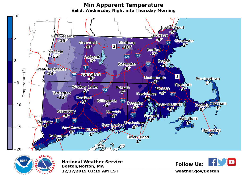
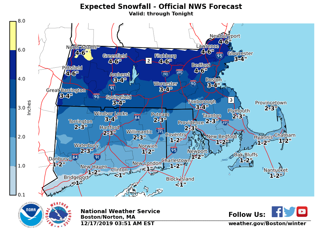
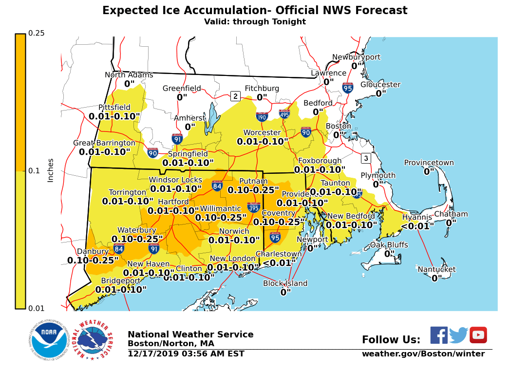
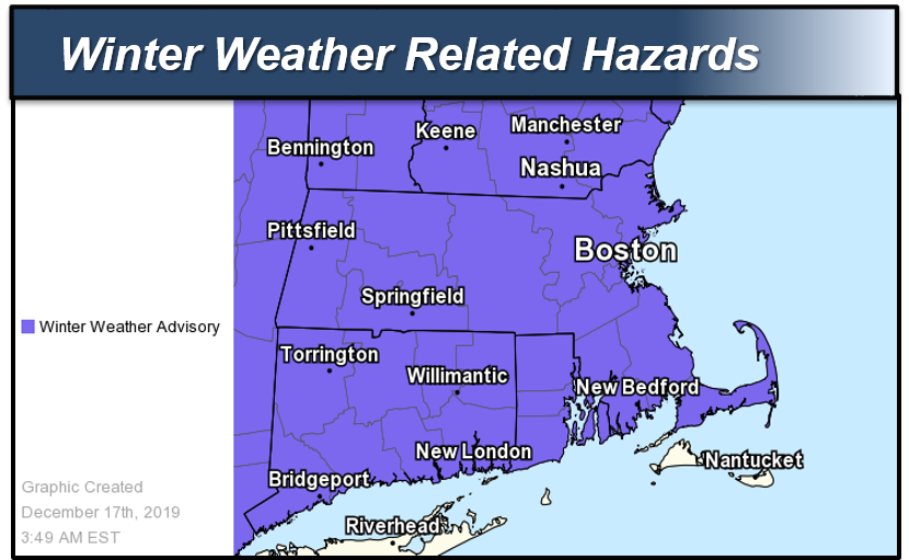
Good morning, Here is the latest briefing for today's winter storm, possible snow squalls Wednesday afternoon/evening and arctic blast for Wednesday night and Thursday. *What has changed:* - Winter Weather Advisory expanded to Cape Cod - Lowered snow accumulations a bit south of the Pike *Accumulating snow and light to moderate ice accretion:* *Locations*: South of the Mass Pike. *Timin*g: Snow changing to sleet and freezing rain this morning with changeover line reaching the Mass Pike around noon. Rain this afternoon along the coast with areas of freezing rain persisting across northern CT, NW RI and adjacent interior MA. *Amounts*: 1 to 3 inches of snow with one to two tenths of an inch of ice accretion focused across northern CT and interior RI. *Impact*: Snow and ice will result in poor visibility and icy roads for the morning commute. The evening commute may also be impacted away from the coast. *Confidence*: Highest confidence for higher ice accretion in Northern CT. *Locations*: North of the Mass Pike. *Timin*g: Snow developing 6-8 am, mixing with or changing to sleet and freezing rain this afternoon, but mainly snow near the NH border. *Amounts*: 3 to 5 inches of snow/sleet. A trace to less than one tenth of an inch of ice accretion, mainly near the Mass Pike. *Impact*: Snow will impact the latter half of the morning commute with poor visibilities and snow covered roads. The evening commute will also be impacted. *Confidence*: Moderate to High. *Isolated to Scattered Snow Squalls:* *Locations*: All locations. *Timing*: Wednesday afternoon into early evening. *Amounts*: A quick coating to half an inch in less than 30 minutes. *Impact*: Temporarily reduced visibility could catch drivers off guard, especially for early evening commute. Also, roads could become snow-covered quickly, resulting in slippery travel. *Confidence*: Low to moderate. Areal extent of snow squalls will be limited with many locations likely remaining dry. Best chance of snow squalls will be in the interior. *Bitter Cold Wind Chills:* *Locations*: All locations. *Timing*: Wednesday night into Thursday morning. *Amounts*: Wind chill values -5 to -20°F in the interior and zero to -5°F in Eastern MA and RI. *Impact*: Coldest air of the season. Bitter cold wind chills for school bus stop. *Confidence*: High. *Potential risk of freezing spray:* *Locations*: Immediate coastal waters off Eastern MA and RI. *Timing*: Wednesday night into early Thursday morning. *Amounts*: Light freezing spray possible. *Impact*: Glaze of ice possible on boats and ships traversing the waters. *Confidence*: Low. Please see the attached graphics for the hazards, snowfall and ice accumulations and minimum wind chill temperatures for Thursday morning. Thank you. Meteorologist: Kevin Cadima If you have any questions or would like more information, don't hesitate to contact us via this email address, on NWSChat <https://nwschat.weather.gov/>, or at the following: National Weather Service Boston/Norton, MA 46 Commerce Way Norton, MA 02766 508.622.3280 Website <http://www.weather.gov/boston> | Facebook <http://www.facebook.com/NWSBoston> | Twitter <http://www.twitter.com/NWSBoston>