
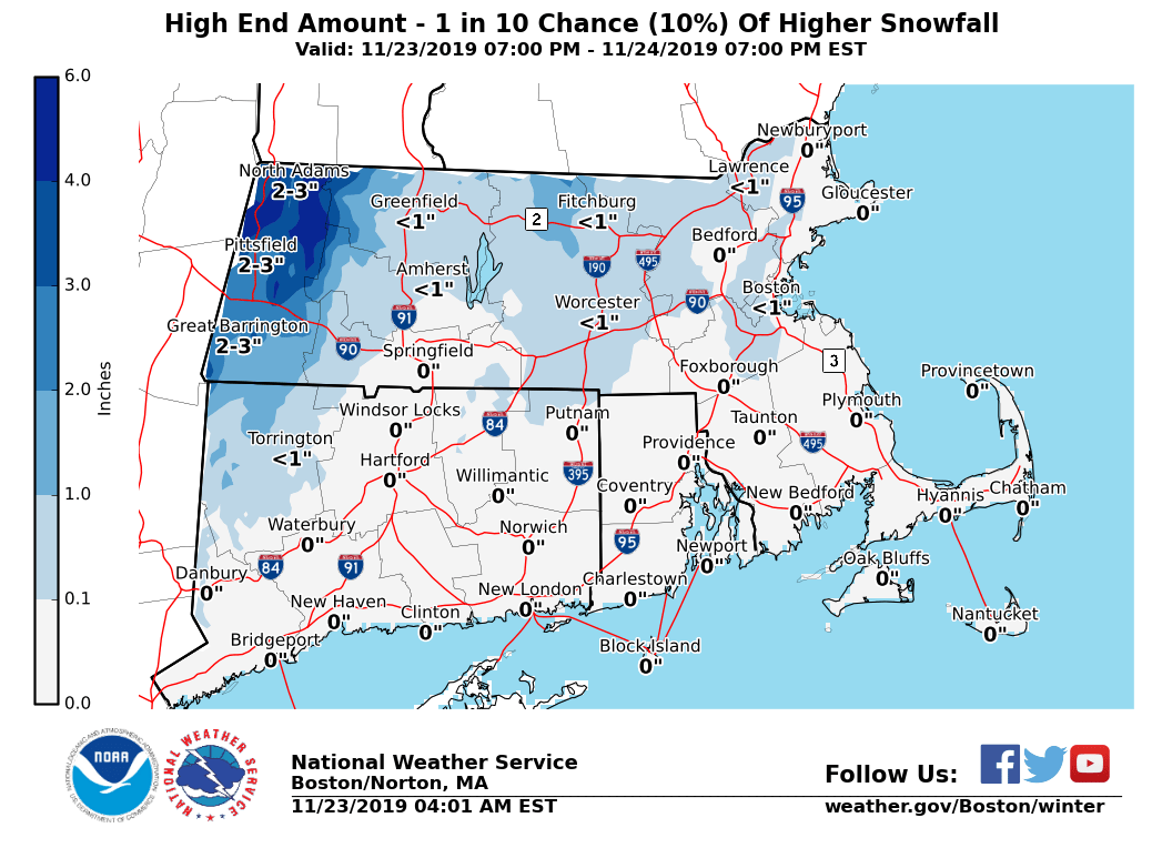
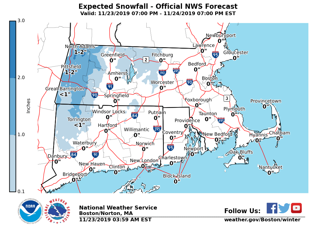
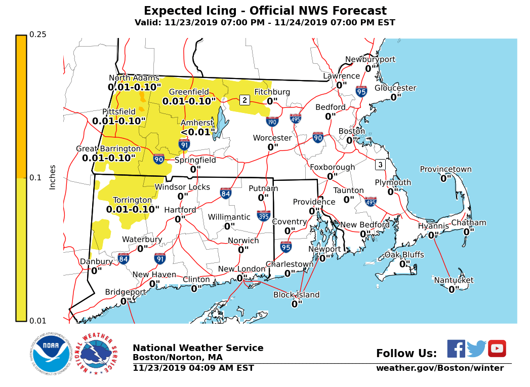
Good morning, Following is an update on potential weather-related hazards from an area of low pressure that is expected to move from the mid-Atlantic through southeastern Massachusetts. This system is expected to produce a wintry mix of freezing rain and snow across the Berkshires into northern Worcester County Sunday, with mainly rain elsewhere in Southern New England. It will also bring a period of gusty winds Sunday night to the coastal waters, along with the potential for minor coastal flooding in parts of eastern Massachusetts during Sunday's high tides. *Changes with this update:* - Gale Watch Issued [Sunday into Sunday Night]: Coastal and offshore waters. - *Updated Snow and Ice Accumulations*. *Note:* Portions of the Berkshires into northern Worcester County *may* need winter weather advisories for parts of Sunday in forthcoming updates. Details below: *Interior Light Icing and Light Snow (See Attached Images):* *Locations*: Mainly the northern Worcester Hills and the Berkshires. *Timing:* Begins as light freezing rain into the pre-dawn hours Sunday morning, changing to rain by late morning or early afternoon. Ending as a period of light accumulating wet snow Sunday night. *Expected Amounts:* A light glaze of ice (up to 1/10"), with up to 2 inches of snow at the highest elevations. *Impact*: Slippery travel. *Uncertainty:* Timing of the exact changeover may affect snow and ice accumulations. *To convey this uncertainty and its effect on snowfall amounts, a reasonable worst-case snow accumulation is also attached (if precipitation to change over to snow sooner); in addition to the expected snow amounts.* *Marine Impacts: Gale Force Winds [Sunday Night]* *Locations*: Massachusetts and Rhode Island coastal & offshore waters. *Timing:* Onset of Gales between 2 and 4 PM Sunday, ending between 4 and 8 AM Monday. *Wind Gusts:* Northwest 35 to 42 knots, peaking between 6 PM Sunday and 2 AM Monday. *Seas:* 4 to 6 feet on the inner bays and sounds; 7 to 11 ft offshore. *Impact:* Hazardous conditions for mariners. *Uncertainty:* High confidence in occurrence, though uncertainty on exact start and ending times. *Minor Coastal Flooding: Sunday Morning High Tide* *Locations*: Eastern Massachusetts coast (including Martha's Vineyard and Nantucket) and the South Coast *Timing:* Sunday morning high tide (5:41 AM at Providence, 8:45 AM at Boston, and 9:46 AM on Nantucket) *Storm Surge:* 1.0 to 1.5 feet *Inundation:* Less than 1 foot above ground level *Impact*: Some vulnerable shoreline roads may become temporarily impassable around high tide. *Uncertainty:* High. Timing of highest surge may not coincide with high tide, which would lead to little or no impact. Minor coastal flooding would be the worst case scenario. *Minor Coastal Flooding: Sunday Evening High Tide* *Locations*: Eastern Massachusetts coast including Martha's Vineyard and Nantucket *Timing:* Sunday evening high tide (9:17 PM at Boston and 10:24 PM on Nantucket) *Storm Surge:* Around 2.0 feet *Inundation:* Up to 1 foot above ground level *Impact*: Some vulnerable shoreline roads may become temporarily impassable around high tide. *Uncertainty:* Lower than with the morning high tide. Locations along the Bay side of Cape Cod, Plymouth County, and Nantucket are most vulnerable. Thank You! Meteorologist: Andrew Loconto If you have any questions or would like more information, don't hesitate to contact us via this email address, on NWSChat <https://nwschat.weather.gov/>, or at the following: National Weather Service Boston/Norton, MA 46 Commerce Way Norton, MA 02766 508.622.3280 Website <http://www.weather.gov/boston> | Facebook <http://www.facebook.com/NWSBoston> | Twitter <http://www.twitter.com/NWSBoston>