
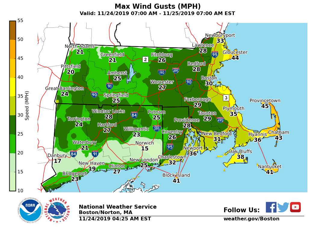
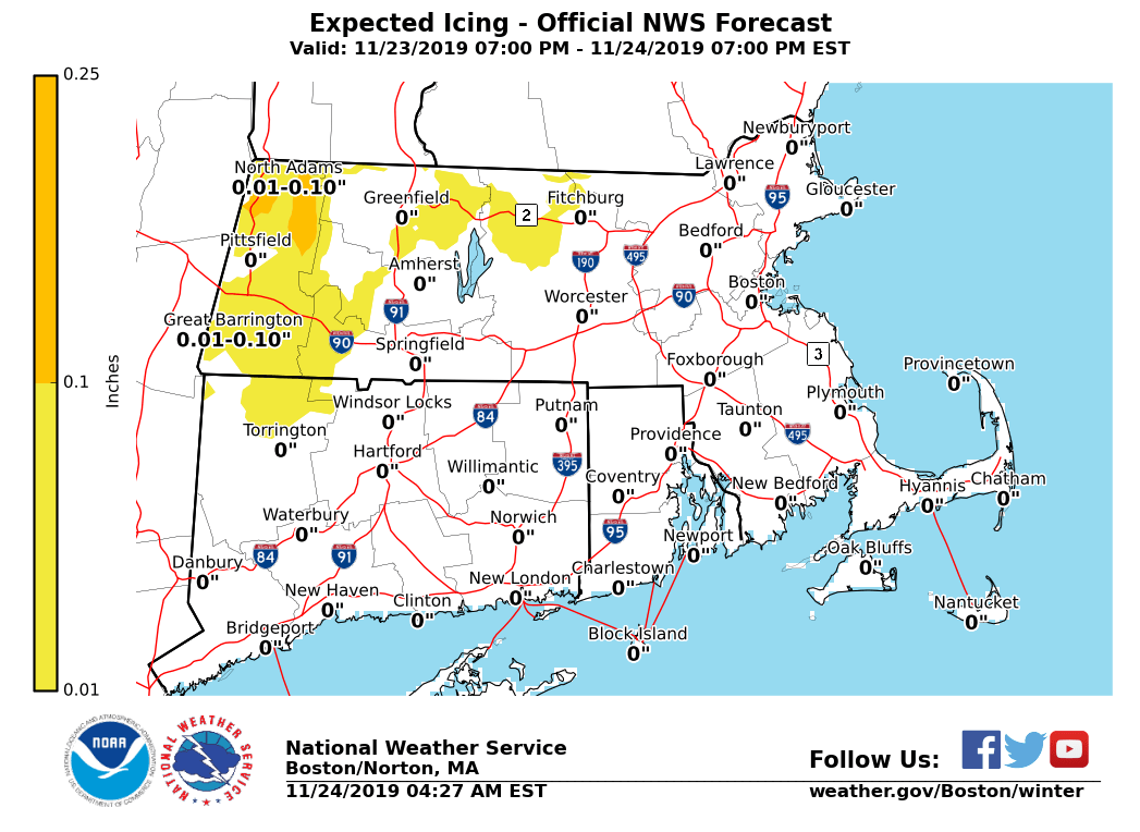
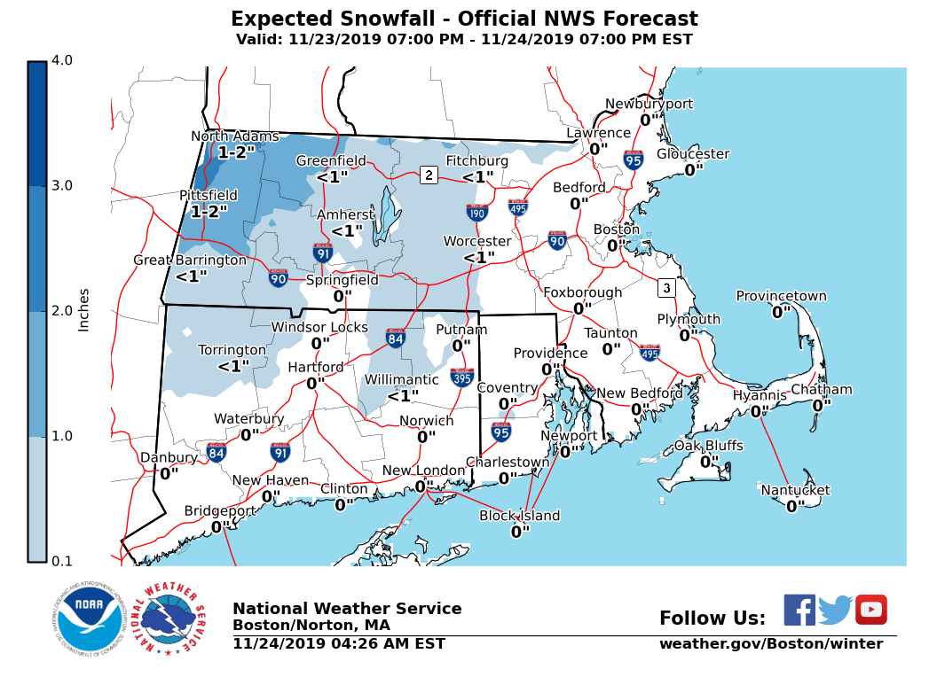
Good morning, No significant changes compared to the information conveyed in Saturday afternoon's briefing. A storm system moving northeast from the mid-Atlantic region is expected to bring a variety of wind, wintry weather and coastal splashover hazards to parts of Southern New England today into tonight. *Changes with this update:* - None. *DETAILS*: *Light Icing and Light Snow: Worcester Hills into the Berkshires* *Locations*: The high terrain of the Worcester Hills and the east slopes of the Berkshires. *Timing:* Ongoing, with wintry precipitation expected to change to all rain by mid-morning. Rain then changes back to wet snow late this afternoon into early evening. *Expected Amounts:* A light glaze of ice (up to 1/10"), with up to 2 inches of snow at the highest elevations of western Franklin and western Hampshire counties. *Impact*: Slippery travel. *Strong Northwest Winds: Coastal Massachusetts, Cape Cod and the Islands* *Locations*: Coastal Massachusetts, Cape Cod and the Islands *Wind Gusts and Timing:* Northwest winds gusting to 40-50 mph. Strongest winds late this afternoon into tonight. *Impact:* Limited. A few unsecured objects may become dislodged, tree branches may be felled resulting in a few power outages. Significant impact is not expected. *Splashover: This Morning's High Tide* *Locations*: Eastern Massachusetts coast including Martha's Vineyard and Nantucket *Timing:* This morning's high tide (5:41 AM at Providence, 8:45 AM at Boston, and 9:46 AM on Nantucket) *Storm Surge:* 1.0 to 1.5 feet *Impact*: Some vulnerable shoreline roads, such as Morrissey Boulevard, may experience splashover around high tide. Significant impacts are not anticipated. *Splashover: This Evening's High Tide* *Timing*: This evening's high tide (9:17 PM at Boston and 10:24 PM on Nantucket) Brief splashover can't be ruled out for tonight's high tide with astronomically high tides. Minor coastal flooding is not expected. *Marine Impacts: Gale Force Winds (Today into Tonight)* *Locations*: Massachusetts and Rhode Island coastal & offshore waters. *Wind Gusts and Timing:* East to southeast wind gusts up to 35 kt Sunday morning, then northwest wind gusting up to 35 to 45 knots, peaking late today into tonight. *Seas:* 4 to 6 feet on the inner bays and sounds; and 7 to 11 ft offshore. *Impact:* Hazardous conditions for mariners. *Please find updated graphics specific to storm total ice and snow accumulations and maximum wind gusts*. Thank you. Andrew Loconto If you have any questions or would like more information, don't hesitate to contact us via this email address, on NWSChat <https://nwschat.weather.gov/>, or at the following: National Weather Service Boston/Norton, MA 46 Commerce Way Norton, MA 02766 508.622.3280 Website <http://www.weather.gov/boston> | Facebook <http://www.facebook.com/NWSBoston> | Twitter <http://www.twitter.com/NWSBoston>