
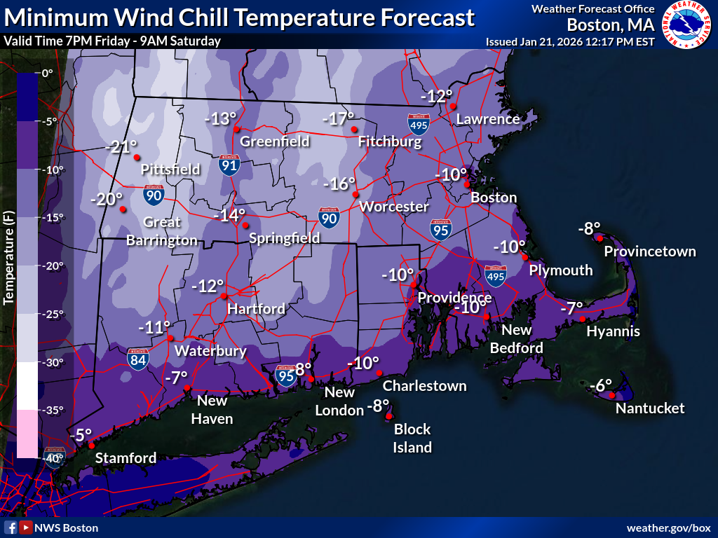
Good afternoon, Just wanted to add a separate attached graphic for the minimum wind chill temperature forecast for Friday night. If you have any questions or would like more information, please don't hesitate to contact us. You can reach us via: email: box.operations@noaa.gov phone: 508.622.3280 Slack/NWSChat 2.0 <https://nwschatws.slack.com/> (for approved partners) social media: Website <http://www.weather.gov/boston> | Facebook <http://www.facebook.com/NWSBoston> | Twitter <http://www.twitter.com/NWSBoston> On Wed, Jan 21, 2026 at 1:10 PM BOX Operations - NOAA Service Account < box.operations@noaa.gov> wrote:
Good afternoon,
Please find attached a one page briefing and supporting graphics regarding dangerously cold wind chill temperatures expected Friday night into Saturday and potentially impactful snow on Sunday/Monday. Additionally find some key points below.
*Dangerous Cold Friday night into Saturday*
- High confidence that an intrusion of arctic air will result in wind chill temperatures between -10 and -20 degrees Fahrenheit Friday night into Saturday.
*Increasing potential for moderate impacts from accumulating snow Sunday-Monday*
- High confidence that portions of southern New England will experience at least moderate impacts from accumulating snow during the Sunday-Monday time frame. - Confidence in specific snowfall amounts is low at this time.
We will provide an updated briefing no later than 10AM Thursday.
Have a great afternoon,
Meteorologists Rob Megnia, Kevin Cadima, and Candice Hrencecin If you have any questions or would like more information, please don't hesitate to contact us. You can reach us via: email: box.operations@noaa.gov phone: 508.622.3280 Slack/NWSChat 2.0 <https://nwschatws.slack.com/> (for approved partners) social media: Website <http://www.weather.gov/boston> | Facebook <http://www.facebook.com/NWSBoston> | Twitter <http://www.twitter.com/NWSBoston>