NWS Boston 11/16 Afternoon Briefing: Coastal Storm Impacts Sunday Night and Monday

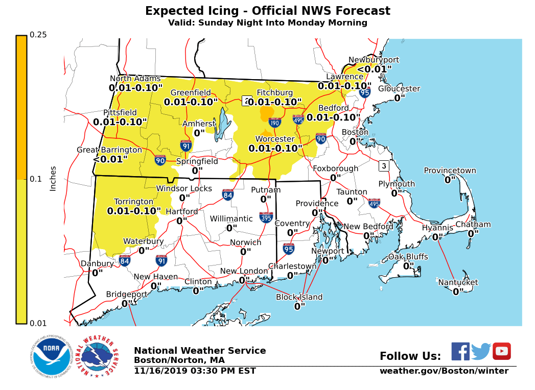
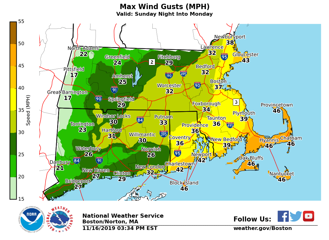
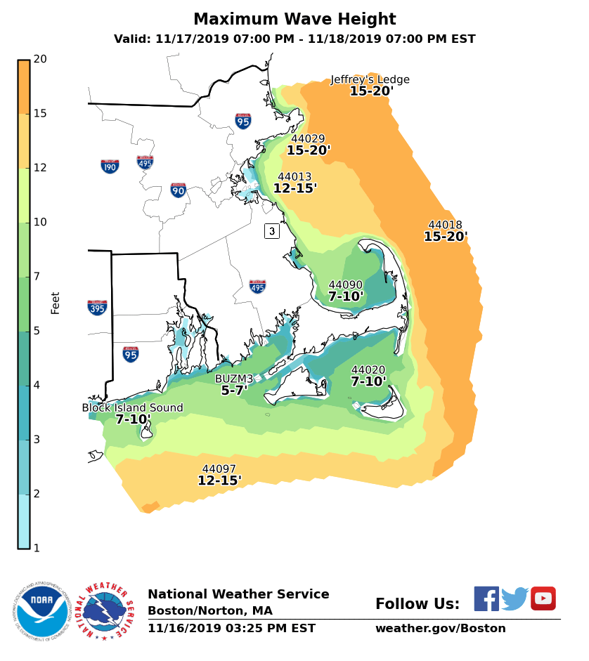
Good afternoon everyone, Little has changed from the previous briefing sent earlier this morning. A coastal storm passing southeast of Nantucket Monday will bring the potential for light icing across parts of the interior, strong winds near the coast, and minor coastal flooding to eastern Massachusetts. Refer to the attached graphics. Here are the details: *Interior Light Icing:* *Locations*: Western and central Massachusetts and part of northern Connecticut, especially in the higher elevations from the east slopes of the Berkshires, Worcester Hills, and hills of Hartford and Tolland Counties. *Timing:* 10 PM Sunday through 10 AM Monday *Amounts*: Up to 1/10 inch of icing *Impact*: Slippery travel *Confidence:* High in light icing across Worcester Hills and east slopes of Berks. Light icing is also possible in the Pioneer and Merrimack Valleys in Massachusetts but temperatures may stay just above freezing in these locations. *Strong Winds:* *Locations*: The Immediate coastline especially Cape Cod and Nantucket. *Timing:* 10 PM Sunday through 10 AM Monday *Sustained Wind:* NE 25 to 35 mph *Wind Gusts:* NE 35 to 45 mph with a few gusts up to 50 mph possible. *Impact*: Minor damage such as downed tree limbs. Perhaps Isolated power outages. *Confidence:* High *Marine Impacts:* *Locations*: Massachusetts and Rhode Island coastal waters *Timing:* 5 PM Sunday through 10 AM Monday on the south coastal waters; 11 PM Sunday to 4 PM Monday on the eastern waters *Wind Gusts:* NE 35 to 45 kt *Seas:* 4 to 9 ft on the inner bays and sounds; 14 to 18 ft offshore *Confidence:* High *Minor Coastal Flooding:* *Locations*: Eastern Massachusetts coast *Timing:* Monday afternoon high tide (3:10 PM at Boston and 4:17 PM on Nantucket) *Storm Surge:* 1.5 to 2.0 feet *Inundation:* Less than 1 foot above ground level *Impact*: Some vulnerable shoreline roads may become temporarily impassable around high tide. Minor beach erosion is also possible. *Confidence:* High. It is unlikely that the storm surge exceeds 2.0 feet so any impacts are expected to be minor. The next update will be sent early Sunday morning. If you have any questions or would like more information, don't hesitate to contact us via this email address, on NWSChat <https://nwschat.weather.gov/>, or at the following: Thank You Meteorologist: Hayden Frank National Weather Service Boston/Norton, MA 46 Commerce Way Norton, MA 02766 508.622.3280 Website <http://www.weather.gov/boston> | Facebook <http://www.facebook.com/NWSBoston> | Twitter <http://www.twitter.com/NWSBoston>
participants (1)
-
 BOX Operations - NOAA Service Account