NWS Boston 11/17 Morning Briefing: Coastal Storm Impacts Overnight Into Monday

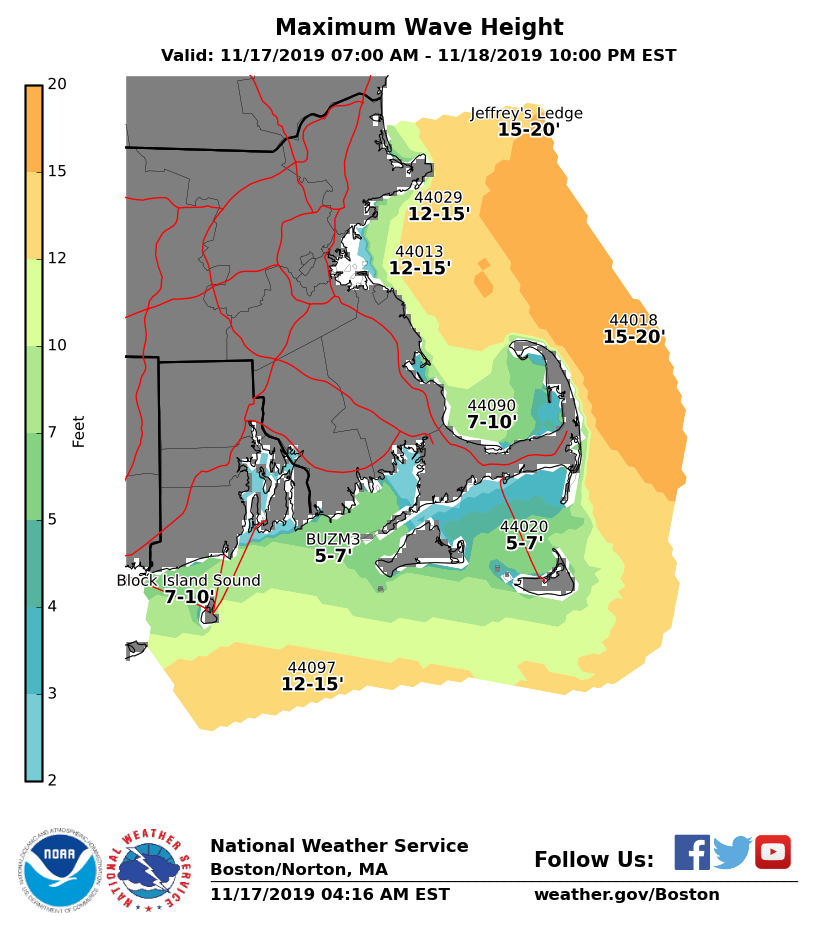
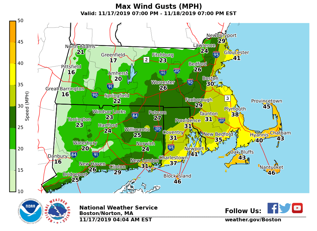
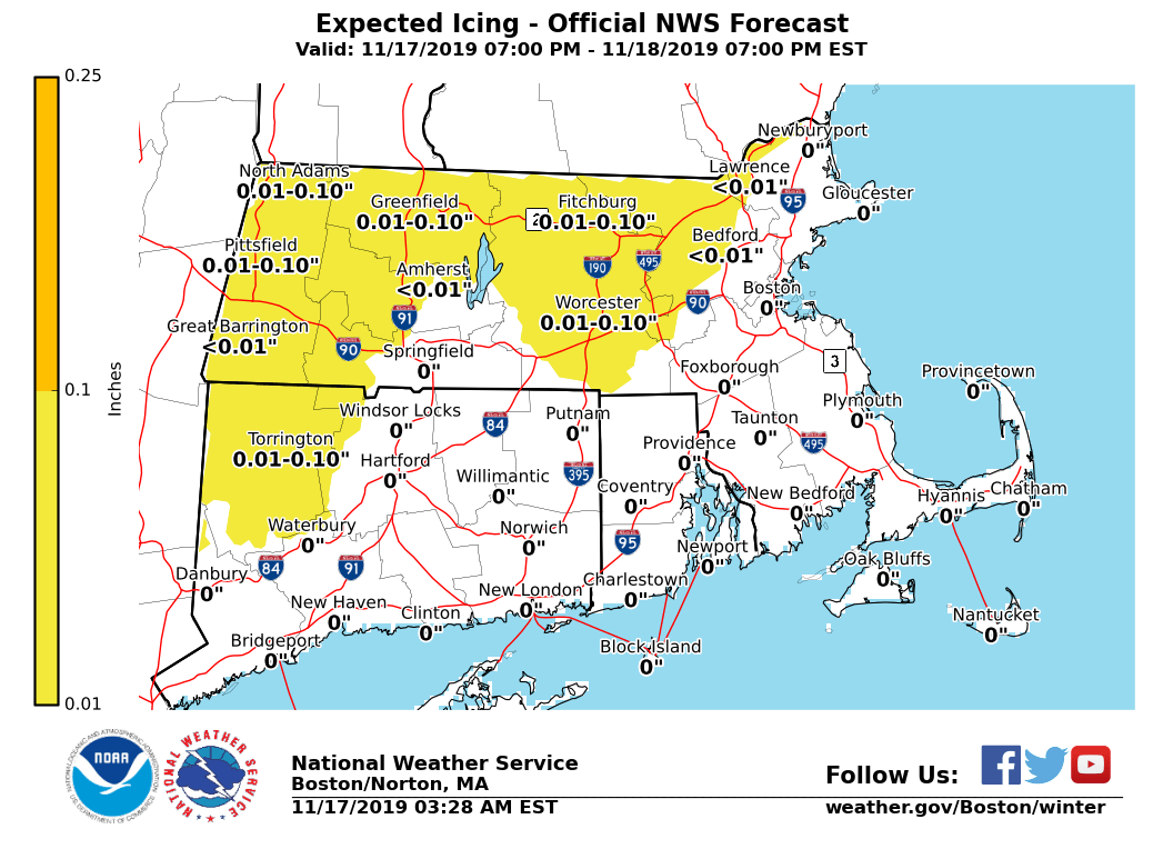
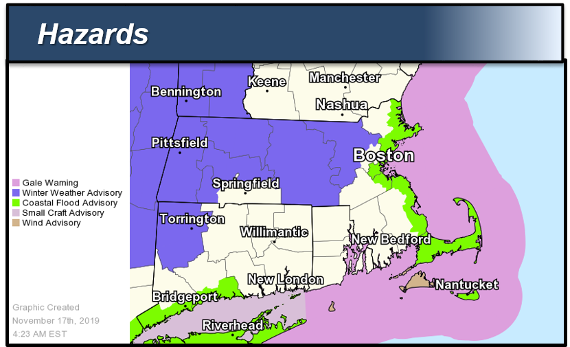
Good morning everyone, Little significant changes to forecast expectations regarding a coastal storm which looks to pass southeast of Nantucket Monday. This coastal storm will bring the potential for light icing across parts of the interior, strong winds near the coast, and minor coastal flooding to eastern Massachusetts on Monday. *Changes from yesterday afternoon's briefing: * - *Winter Weather Advisory Issued[*Midnight Thru Noon Monday]: Franklin, Hampshire, Worcester and Middlesex Counties in MA due to light ice accretions. *Note:* Expansion of the Winter Weather Advisory *may* be needed in later updates into Hampshire, Hartford, Tolland Counties in western MA and northern CT, and into western Essex County in eastern MA. - *Wind Advisory Issued*[1 AM Thru 5 PM Monday]: Dukes and Nantucket Counties in MA and Block Island in RI for strong northeast winds. *Note:* Expansion of the Wind Advisory *may* be needed in later updates for Cape Cod. - *Coastal Flood Advisory Issued*[2 PM to 5 PM Monday]: Eastern MA coast, Barnstable and Nantucket Counties for minor coastal flooding at/around the Monday afternoon high tide. Details below: *Interior Light Icing:* *Locations*: Western and central Massachusetts and part of northern Connecticut, especially in the higher elevations from the east slopes of the Berkshires, Worcester Hills, and hills of Hartford and Tolland Counties. *Timing:* Midnight through 10 AM Monday *Amounts*: Up to 1/10 inch of icing *Impact*: Slippery travel, impacting Monday AM commute. *Confidence:* Highest confidence in the Winter Weather Advisory area of light ice accretions. A brief period of freezing rain is possible in western Essex County MA and into Hartford & Tolland Counties, but lowered confidence in these areas due to potential for temperatures remaining just above freezing. *Strong Winds:* *Locations*: Mainly Dukes and Nantucket Counties into Block Island, and Cape Cod. *Timing:* 1 AM through 10 AM Monday. *Sustained Wind:* NE 25 to 35 mph. *Wind Gusts:* NE 35 to 45 mph with a few gusts up to 50 mph possible. Gusts to 40 mph across Cape Cod. *Impact*: Minor damage such as downed tree limbs. Perhaps Isolated power outages. *Confidence:* High across the Islands, lesser/moderate confidence for Cape Cod. Greatest potential for wind gusts capable of minor impacts toward the Islands, but may be possible for Cape Cod. *Marine Impacts:* *Locations*: Massachusetts and Rhode Island coastal waters *Timing:* 5 PM Sunday through 10 AM Monday on the south coastal waters; 11 PM Sunday to 4 PM Monday on the eastern waters *Wind Gusts:* NE 35 to 45 kt. *Seas:* 4 to 9 ft on the inner bays and sounds; 14 to 17 ft offshore. *Confidence:* High. *Minor Coastal Flooding:* *Locations*: Eastern Massachusetts coast *Timing:* Monday afternoon high tide (3:10 PM at Boston and 4:17 PM on Nantucket) *Storm Surge:* 1.5 to 2.0 feet *Inundation:* Less than 1 foot above ground level *Impact*: Some vulnerable shoreline roads may become temporarily impassable around high tide. Minor beach erosion is also possible. *Confidence:* High. It remains unlikely that the storm surge exceeds 2.0 feet so any impacts are expected to be minor. Updated storm total ice, maximum wind gust and maximum wave height graphics are attached, as well as an overview of issued hazards. Next update will be sent Sunday afternoon. Meteorologists: Andrew Loconto and Kevin Cadima If you have any questions or would like more information, don't hesitate to contact us via this email address, on NWSChat <https://nwschat.weather.gov/>, or at the following: National Weather Service Boston/Norton, MA 46 Commerce Way Norton, MA 02766 508.622.3280 Website <http://www.weather.gov/boston> | Facebook <http://www.facebook.com/NWSBoston> | Twitter <http://www.twitter.com/NWSBoston>
participants (1)
-
 BOX Operations - NOAA Service Account