[2019.12.30 4 AM Update] NWS Boston EM Briefing: Severe Icing Threat & Wintry Mix Thru Tonight

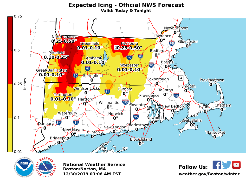
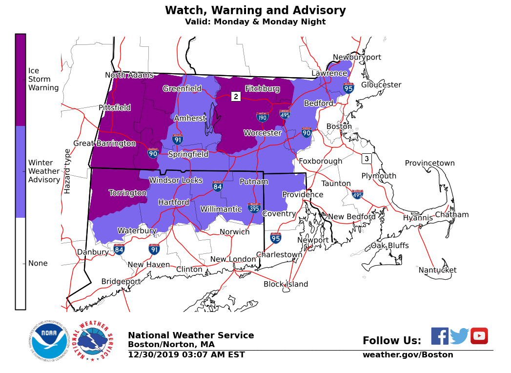
Good morning, Here is the latest information on a storm that is currently ongoing across Southern New England early this morning. We are still expecting significant/severe higher-elevation icing for the Berkshires into northern Worcester and northwest Middlesex Counties through tonight. Lesser, though still impactful icing is still anticipated for most areas west of Interstate 495. *What has changed:* Winter Weather Advisories which were previously in effect for eastern Massachusetts and central Rhode Island have been *cancelled*. Freezing rain is no longer expected to impact these areas. Mainly rain is now anticipated for these locations. Due to warmer surface temperatures, reductions in ice accumulations were made. Significant icing is still expected in the higher terrain in the Berkshires into northern Worcester County. *Current Watches/Warnings/Advisories in effect:* All warnings and advisories over land are in effect from tonight through Tuesday AM - *Ice Storm Warning **for the eastern slopes of the Berkshires, northern Worcester County and northwest Middlesex County.* Here is where the most significant icing is expected due to a long duration of freezing rain. Severe impacts can be expected with extensive power outages and tree damage. This morning's commute will be treacherous in these areas, with continued impacts into this afternoon's commute as well. - Winter Weather Advisory *for northern CT, northern Providence County in RI and across western, central and northeast MA west of I-495*. Mix of precipitation types for these areas. Expect lesser, but still impactful accretions of freezing rain and sleet. This morning's commute will be slick for these locations, with slickened roads still possible into this afternoon's commute. *Marine Watches/Warnings in effect:* - *Gale Warnings* for all of the coastal waters except for Narragansett Bay, through early Tuesday. *Main Weather Concerns: * 1) *Severe icing across the higher elevations* *of* *western and north central MA through tonight*. Coverage of freezing rain will continue to expand early this morning and last into Monday evening. For the slopes of the Berkshires, we still expect to have one half to three quarters of an inch of ice with isolated amounts up to three-quarters of an inch. In northern Worcester and northwest Middlesex Counties, one-quarter to one-half inch of ice with isolated totals to two-thirds of an inch. East to northeast winds will increase today, with gusts of 20-30 mph in the higher terrain by late afternoon. This, coupled with the ice, could worsen the impacts. By Tuesday, temperatures increase into the upper 30s and low 40s in the higher terrain allowing for melting. 2)* Lower elevations: Lesser amounts of freezing rain (with some limited periods of sleet at times) through today. *Accumulations of freezing rain and sleet will continue to expand in coverage, and impact this morning's commute. Additional light icing may impact this afternoon's commute as well. Icing amounts range from a light glaze to one-quarter inch. 3) *Strong east to northeast winds* are expected over the coastal waters and along the South Coast this afternoon into tonight. Expect gusts of 40-45 mph across Cape Cod and the Islands tonight. *What we are uncertain about:* *Moderate to high confidence:* - Uncertain on the duration and exact precipitation type outside of the Ice Storm Warning areas. - Uncertain on the areal coverage and duration of sleet. With the tendency for warmer temperatures, freezing rain and/or rain should predominate as weather types with less sleet. Attached images include the updated Winter Hazards in effect, and an updated Storm Total Ice forecast based on our morning forecast. Meteorologists: Andrew Loconto and Frank Nocera If you have any questions or would like more information, don't hesitate to contact us via this email address, on NWSChat <https://nwschat.weather.gov/>, or at the following: National Weather Service Boston/Norton, MA 46 Commerce Way Norton, MA 02766 508.622.3280 Website <http://www.weather.gov/boston> | Facebook <http://www.facebook.com/NWSBoston> | Twitter <http://www.twitter.com/NWSBoston>
participants (1)
-
 BOX Operations - NOAA Service Account