
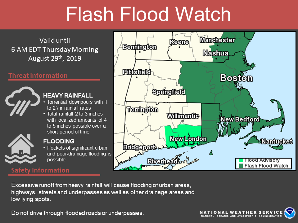
Good afternoon, There are no changes to the forecast regarding the heavy rainfall and risk of flash flooding. A FLASH FLOOD WATCH continues for central/eastern MA and RI where confidence is highest for heavy rainfall and localized flash flooding. Details below. *What:* - Heavy rainfall with rainfall rates 1-2 inches/per hour - Total rainfall of 2 to 3 inches, with localized amounts of 4 to 5 inches over a short period of time - Pockets of significant urban and poor drainage flooding possible - Low risk for an isolated severe storm *Where:* - The greatest risk across eastern MA and RI, but axis of heavy rainfall may still shift slightly *When:* - Heaviest rainfall will be tonight through the early morning hours - Best chance for an isolated severe storm will be tonight *Uncertainty:* - The heaviest rainfall amounts and potential flooding will be localized, and thus amounts will vary considerably over short distances. However, the greatest confidence lies within the Flash Flood Watch area. If you have any questions or would like more information, don't hesitate to contact us via this email address, on NWSChat <https://nwschat.weather.gov/>, or at the following: National Weather Service Boston/Norton, MA 46 Commerce Way Norton, MA 02766 508.622.3280 Website <http://www.weather.gov/boston> | Facebook <http://www.facebook.com/NWSBoston> | Twitter <http://www.twitter.com/NWSBoston>
participants (1)
-
 BOX Operations - NOAA Service Account